Wednesday, December 28, 2011

3pm UPDATE: Apple Creek Road

(Salting update below in RED)

Just my take on the road from this afternoon's ride....

I went out on errands in an AWD car at 1:30 pm and returned by 3pm, driving all the way to the top.

The double hairpins below the mirrored corner were in nasty, black ice shape, with tracks of someone coming perilously close to sliding off.  I had taken along two bags of salt from home and thoroughly salted the two curves, and upon returning they were significantly improved.  The salt is good for 10 degrees, so while refreeze will occur tonight, the brine should keep those curves in passable shape.

Just past Staymon Road, heading up the mountain, Apple Creek Road is basically all lightly snow covered ice, but a very roughly shaped ice.  I drove all the way to the gate and back down and didn't slip once, taking it even and slow as one should in these conditions.  Not much melting going on in many of the higher areas, so refreeze means the same situation for the morning, the roughness helping for grip, but no sheets of smooth ice.

From the hairpins down, just a few little slick spots, but otherwise the road is fine.

Temps should go up nicely tomorrow afternoon.  

Update: By 8pm or so, Apple Creek Road will be salted from Staymon Road on up, with a splash of more salt on the hairpin curves salted earlier this afternoon, as the salter comes back down.

bob

1:20AM UPDATE - SNOW/ROADS

(Updates in RED below)

Still lightly snowing at this hour, with slightly less than an inch outside.  My driveway is white, so I'll assume Apple Creek Road is, as well.  We all have seen how slick even a quarter to half an inch of snow can be, so keep it slow and steady if you're heading out...I'll also assume John Stoeckel would post here if/when salting is scheduled. It will stay bitterly cold and below freezing until Thursday afternoon, so what snow is out there won't be going anywhere for a while.

Haywood County is under a Winter Weather Advisory until 9am for elevations above 3500' (our blue roof house), though the NWS wording is more for the TN border peaks and roads.  1-2" expected there along with increasing areas of black ice forecast.  ACA has been in the ~1" category all along.

7:45am ROAD REPORT from Al Rose:
From the top of ACA down to the mirrored curve is basically an icy base with light snow cover.  The ice has a rough texture, so there is some grip to be had.  From the mirrored curve through the big hairpin curve are some icy spots, but the road starts improving.  From the Damon's (#579) down has some slick spots, but Al said a front-wheel drive should be able to even go up with no problem.  Slow and low (as in gear) and all should be fine.  Just a cold and breezy day ahead, warming up almost immediately tomorrow. 

9:00am update from visitor:
(in front wheel drive Acura)  snow-covered ice through the mirrored curve, then some black ice on the hairpins below; otherwise, lower Apple Creek Road is mainly clear, outside of other smaller icy patches.
 

bob

Tuesday, December 27, 2011

Today's weather: Dec. 27

Just measured 0.67" of rain as the heavier stuff is now ending.  Plenty of showers still back to the SW to pass through today, and around supper time this evening snow is forecast to start mixing in.  By tomorrow morning there could be a minor amount of snow on the ground, certainly for the upper half of ACA.  

Ground and roads are warm, of course, and not expecting any travel issues here in ACA, even with temps falling below freezing later tonight and staying below through Wednesday.  Just FYI and the usual caution for anyone heading out before light tomorrow as there could be light snow on the road.  

This graphic was sent out by the NWS office in Greer this morning.  ACA is on the edge of the lightest fluff in Haywood.

CLICK TO ENLARGE
bob

Sunday, December 11, 2011

Blog etiquette and rules

This blog is used for information purposes, only.  Any reader may post in the 'comment' section to provide worthwhile information, updates, or to simply ask questions for clarification.  Someone wishing to complain about certain events and situations in ACA are to write their grievances to the president of ACA HOA (John Stoeckel); they will be taken up by the board at their next meeting, and you will receive a written response.  Posts in violation of these rules will now be deleted.

For various reasons some may not be able to successfully post with a listed account (g-mail or otherwise) and can thereby use the 'anonymous' log-in to do so. HOWEVER, your name will be required at the end of the post or it will be deleted.  Unnamed/uncredited posts will now be deleted.

NO POST shall be accepted whereby disparaging personal remarks are made against others; take your opinions and contact that party directly, off-blog.  Such posts will now be deleted.

In summary, inappropriate behavior/commentary will not be accepted or acknowledged herein.  Thanks to all in advance for being responsible users of this site.


Wednesday, December 7, 2011

ICING concerns and SALTING

Hit 32 degrees at my house around 520p, and ice is already all over my deck...while some limited snow accumulation is possible, my concern is for black ice and travel tonight through tomorrow morning.  With that said, I have someone new coming in by 9pm to lay down salt on Apple Creek Road, which should protect us through this time period.  Just a heads up for a salting rig if you're out and about then.

Even if some snow falls on the roads, the warm ground temps will help melt it as well as the ice, so not anticipating any plowing needs at this time.

Will update as necessary.

Bob

WEDNESDAY AM snow update

(one updated sentence added in blue)

WINTER WEATHER ADVISORY is in effect for ACA starting 4pm this afternoon through 7am Thursday.  NWS snowfall guidance is pretty much in line with my two favored models, the 1-3" range, with the higher amounts here above the blue roof house.  Even the GFS model the past two runs has pulled back from a high of 5" to just 2".  Snow will start mixing in with the rain late this afternoon and switch over to all snow later.  I expect our air temperature will hit or be below freezing by 6pm.
The Good News:  ground is warm, and much of the snow will melt from temps and rain, which is why the snow totals are fairly minimal and only at advisory criteria.  Too, once it's cold enough for all snow to fall, there won't be that much moisture left in the system. 
The Bad News:  Ice. Black ice, developing overnight through Thursday morning, and it could be a huge problem here in ACA.  There won't be enough snow on the road to plow, I don't think, so it may need to be salted.  However, I always call ice "the Great Equalizer" as it can stop any vehicle, and it may be a truck couldn't get up to do the salting.  NOTE:  Be VERY careful coming out of your house late tonight/tomorrow morning as driveways, decks, stairs are almost guaranteed to be dangerous.  

The Other Bad News:  Wind, and lots of it.  So far at 8:45am I've recorded 3.47" of rain the past couple of days.  Water is all over our road, and Al Rose reported water covering parts of Mauney Cove Road and rivers running down highway lanes.  The ground is super-saturated and trees could easily come down when the wind fields move in, which raises the specter of not only power outages but blocked roads.

Thursday's weather is a high back into the 40s with sunshine.  One can argue this is a minor system, but we'd all rather deal with snow and not ice.  luckily neither will hang around long this time.

Please be careful.

bob

Tuesday, December 6, 2011

Incoming SNOW potential

In some sense, this next incoming system already in progress will spare us compared to what it's doing in the central section of the country right now, and what it will do to the Northeast by the end of the week  with a big nor'easter.  Temps are very mild, lots of rain yet to fall later today and tomorrow, but the crashing cold looks to arrive Wednesday after dark with enough leftover moisture for a few inches of snow here in ACA.

Originally the models were keeping ACA in the dusting to maybe 2" up high, with 2x to 3x more just 10-15 miles away toward the TN border.  However, the trend the past 36 hours has been to slightly up snow totals away from the TN border.  For the last system  the NAM showed more snow than the GFS, but this time it's reversed.  Here are this morning's projection:

NAM:  1-3"      GFS: 2-5"
onset (right now) is around 10p Wednesday, tapering off Thursday morning.  Higher total potential only for areas above 3500' elevation (blue roof house).

Good news:  like last time, we've got warm temps, air and ground, so a lot may melt or not stick on the road right away.  From the last system I collected about 1.5" with none ever collecting on my driveway.  Makes sense that if there are road issues developing it would be well before sunrise Thursday morning.

11-29-11 snow in progress on Staymon Road
 Bottom line: not a big system, but the minor wild card will be the low re-forming off the Carolina coast, winding up to be a big nor'easter as it moves up the coast.  IF it were to strongly do so and initially move slowly, that may be where the GFS is seeing the bigger snow for us.  The 'whammy' from this system will be well to our north and the interior of the Northeast, though, so am thankful for the factors we have working against a big issue here in ACA.

Bob

Tuesday, November 29, 2011

Tuesday 4AM

Round 1 has left us with no snow, but Round 2 will develop through today and tonight.  The NWS has us under a winter weather advisory for 1-3" possible, with the highest amounts at the higher elevations.

CAUTION!  My temp is 30 degrees, and I walked out on the deck and probably set off the seismograph in Asheville as I fell hard due to a glazing of ice on all surfaces.  Be very very careful stepping out.

At the moment the radar is pretty empty, though a lot of the incoming snow clouds will be low in altitude and not show up well.  I'll post updates as needed today.

bob

Monday, November 28, 2011

Monday AM UPDATE:

Hitting the road shortly back to ACA, but wanted to update what we can expect weather-wise in ACA.  What's complicating the potential snow forecast is the timing of the cold air arrival with the last of the heavier rainfall overnight TONIGHT. Plenty of rain yet to come to ACA, but the updated model still has enough cold air to make Tuesday morning an issue.  Snow onset will be in the overnight hours, and should be going nicely by midnight. 

There is a kinda-sorta second part of this storm that will continue to keep snow in the forecast for the Tuesday evening and overnight hours.  Potentially more road issues, Tuesday evening through Wednesday morning.

NAM run for early this morning is holding tight to 2-5" around ACA.  The latest GFS run isn't done yet, but it's consistently been at 1" tops.  The NWS is talking of only light accumulations (1") above 4-5K feet at this time...but I also just now saw where winter storm watches are posted for the areas in MS and TN I wrote in the prior post.  Their NWS offices weren't discussing snow when the NAM was peppering them with lots of snow, so it may well be our 'light looking' forecast might lean a tad more towards the NAM later today. (click pic to enlarge)

NAM early Monday run
For now, I am going to stick with my up to 3" for the top of ACA, and 1" for the bottom of ACA for a storm total.  Road issues should develop before sunrise tomorrow, Tuesday.  My best guess, for now.

Bob

Sunday, November 27, 2011

Snow update

I'm here in Charlotte pulling the AM shift, and culling over the latest snow forecasts.  National Weather Service isn't mentioning much of anything at the moment, but while flip-floppy and a tad erratic, the NAM continues to put ACA in a 2-3" range, with the GFS around 1", maybe 2" up high here.  Heck, the NAM continues to show quite the quick hitting winter storm in northern MS, southern TN, and NW AL with hefty snow amounts.  However, the NWS there is saying ground temp and air temps will be too warm for much accumulation if any...I dunno 'bout that one...

One factor limiting accumulations here will be how much rain mixes in with the snow onset around midnight Monday, when the precipitation will be heaviest.  The chance of snow stays around all of Tuesday and Tuesday night, though moisture becomes more and more limited.  Seems to me it's reasonable to say 1" down low and 3" up high in ACA at this time, though I'll update either late today or early Monday AM.  Those accumulations would be for when all is said and done.

One can argue 2" of snow isn't anything, but even 1/2" on Apple Creek Road can be a huge travel problem, hence being concerned.  Especially starting with rain, then temps freeze, icy bottom layers to snow become a bigger concern.

NAM early SUNDAY map
GFS early SUNDAY map
Bob

Saturday, November 26, 2011

Heads up....

Early next week just might be our first accumulating snowfall in ACA.  Breezy and rainy conditions will move in Sunday through Monday, with colder air coming in later on Monday.

If there is going to be a problem, it will develop Monday night (though snow might mix in with rain late in the day) and go into Tuesday as goodly amounts of moisture potentially will wrap around the low moving into the NE.  The most preliminary of 'looks' in my favored models paint a crazy amount of snow for ACA, which would be silly to buy into this early...but when the NAM starts spitting out 5-8" right over us, I can't ignore it.  The GFS is gentler in the 1-3" range, but both are showing the white stuff.

So for now, just putting it out there and you'd do well to keep checking back as that time frame approaches. If you have not already done so, you might like to read my October post on how I/we handle snow issues in ACA: click HERE.


bob

Tuesday, November 8, 2011

"Boomers..."

The post prior to this is for the Damon's lost cat "Bootsie"...please read if you haven't done so already.  I referred to 'boomers' in a comment on that post, and since I recently got some cute pics of one taunting Molly, figured I'd post 'em here.  Old timers in the mountains have called these little Red Squirrels 'boomers' ever since I can remember.  They are mainly higher elevation squirrels, and cross over very little with lower elevation Gray Squirrels.  I'm at 3775' and only this summer did the first Gray in 3 years show up here...Boomers abound, as do Chipmunks.

Click on pics to enlarge...keep in mind between my lens and the boomer was Molly, knowing she didn't have the speed to actually catch the furry critter.


FOR SCALE, NOTE BOOMER ON TOP CORNER OF THE ROCKING CHAIR

Bob

Monday, November 7, 2011

Lost Cat in ACA

The Damons on Apple Creek Road have recently lost their cat and are asking for any information anyone may have per sightings, noises, etc.  Their flyers are posted around, as well.    Bob
------------------------------------

Bootsie is a medium-sized, shorthaired Gray Tabby w/ Black Stripes, Green Eyes, and White Boots last seen wearing a black collar with a green tag and has a shaved belly (spay surgery).    She's generally friendly but may run from strangers. Last seen: November 1, 11pm on Apple Creek Rd

Call day or night: (703) 568-9302 if you spot our Bootsie or if you have heard cats fighting recently, caterwauling, or meowing.

Friday, October 28, 2011

Tonight....

Not necessarily worth mentioning, but TV and radio are throwing the S-word around.  For ACA, flurries, light snow might dust our higher reaches overnight into the morning, but travel shouldn't be impeded unless the icy mix inbetween the rain and snow put down a light glaze just before sunrise.  Lows may not actually hit 32, but for anyone heading out early Saturday morning, take heed to check the roads, your temperature, etc.  I do see 1-2" for Mt. Sterling (northern Smokies pretty close by) and 2-3" along the TN border north of Asheville, well out of our hair.  Otherwise, just a cold hit that fairly quickly modifies over the weekend.  Hey, at least we're not in that northeastern snow!

bob

Monday, October 24, 2011

Winter Outlook 2011-12

The National Weather Service put out it's official winter outlook that basically runs from December through February.  While it's a La Nina winter in terms of the big Pacific current that helps get our weather balls rolling, western North Carolina finds itself in the good ol' quasi-zone of 'equal chances' for cold or not and snow or not.  Sounds good and vague to me, but at least we aren't in a bull's eye for extended cold weather.


As we say in the biz, let's hope for the best and be prepared for the worst.  Click on the following graphics to enlarge 'em.

Bob

Sunday, October 23, 2011

About BLOGGER....

 As the old saying goes, "Computers: can't live with 'em, can't live without 'em".  Linn had written in on the last post about becoming a 'follower' or 'member' confusion per our blogsite, and as I looked into it, I was surprised to see first and foremost how the different PC browsers vary in displaying our site.  I'm guessing if you subscribe as a 'follower' you are then a 'member' (feel free to correct me if I'm mistaken).  Too, Chris, I know you are a MAC Daddy so I don't know how the site looks on your end...feel free to chime in.


For each of the pictures you can click on them to enlarge, and the area in question is on the right side.  Not much else I can say about it, except to make you aware of how different they appear.  I use to use Firefox a lot, but have switched to Chrome...put in samples for IE and Opera, as well.


Firefox and Opera are comparable, but lots of missing 'stuff' in Chrome and IE:


Bob

Tuesday, October 18, 2011

A snow 'primer'....

(NOTE: forgot to add the paragraph below in this blue type)

To save you from going back to old blog entries, and for the newer readers, I wanted to pass along how I keep abreast of potential winter weather.  To listen to WLOS or the radio or read a generic website will often give very incomplete information, if not misleading and/or incorrect.  When I post here, it is specific to Apple Creek Acres, our general N/NE exposure, and attention to our elevations which start at ~2880' at the entrance to ~3900' at the top.

The Moskos family lives in what most of us refer to as the 'blue roof' house, and that's important because they are pretty much at 3500'....ask anyone here, a LOT often happens at that elevation per winter weather problems.  You'll see me talk of issues above or below that location often.

Got an email today that the National Weather Service will release their upcoming Winter Outlook this Thursday morning, the results of which I'll pass along.  We've had two very hard winters in a row here, in terms of prolonged and numerous snow and icing events at ACA.  Many have to drive Apple Creek Road daily, so keeping our roads safe and passable is of paramount concern, though not always easily attainable when circumstances get beyond our control.

With that said, John Stoeckel makes the call for plowing and salting, and Claire will post any information on planned times for those events immediately when they know them, so check the website.  It is wise if you select to "follow" this blog (upper right 'join this site')...your info is private and not shared...but you'll get an email that there is a new post to read, so you don't have to check willy-nilly and maybe miss timely information.  Just a friendly suggestion.  :-)  NOTE:  Blogger can be a real pain and not display the above option...if you do not see it, refresh the screen or try again later.  Things show up inconsistently, unfortunately.

Wednesday night and again on Thursday night, temperatures will be approaching the freezing mark, at least above the blue roof house (see what I mean?).  I won't be a bit surprised to see snow mixing in with any showers (especially after midnight), but I do not expect any accumulation.  As the crow flies we're close to the Smokies and the Plott Balsams, and they could eek out an inch or two, according to one of the models I follow.

Ah, the models.  I will refer to them simply by their acronyms, the NAM and the GFS.  The NAM has pushed the snow idea for a couple of days now, but the GFS still is not showing any (outside of one run yesterday). 'Runs' occur 4 times a day, so when we're in 'alert' mode I check them often and compare trends, updating this blog as needed.

While we'll see no travel concerns from any of this, suffice it to say I'm going to have to switch from shorts to long pants for a while.  It will be significantly colder, and the winds won't help the situation.  It all calms down and warms up by this weekend, but after these gorgeous and mild days, it'll be a bit of a shocker.

Oh, and I often post a gratuitous 'cool' shot of something I've taken....this was last week after morning fog lifted over head and made for some neat sun shafts in the woods beside me....for any picture or graphic I post, you can usually click on it to enlarge some.


Bob

Monday, October 10, 2011

October update

Now that the updated and amended minutes from our annual meeting have been mailed out, I wanted to welcome the new viewers to this blog.  I will only put weather information up when it's of a serious concern, for travel or otherwise, but we've not had a lot in the 'worrisome' category of late.  


The color is getting ready to explode, though we have a couple of days of rain moving in as I type.  Above pic is from a Sugar Maple by my house...as with any pics on any blog post, you can click on them to enlarge them.  The National Weather Service says we're in store for a milder, less snowy/icy winter...what a novel idea, after two seriously snowy and cold winters in a row with snow totals in the 50-60" range here in ACA (at least above 3500').  With that said, while I have NOT seen overly active bees and yellow jackets as I have in the past, I can honestly say I've NEVER seen the amount of chipmunk and squirrel activity that I've been seeing in ACA...it's borderline 'other worldly'.  Since I've not been able to afford even a used 4WD vehicle, I'm oh-so-hoping this winter is kinder.

Early on I posted some suggestions for close-by trips if you have company in town and looking for something unique to do.  I have two suggestions that are 'user-friendly' for pets and those that have ambulatory issues.  My knees are very bad, but even these two treks were do-able, and they're both pet-friendly (should use a leash, though).  Of course, there are scads of neat places to go in our area, but these two are 'up there' on my list, best enjoyed on days and times where crowds are a bit more minimal....oh, and the weather is good!


Max Patch Bald is a big favorite for many...the Appalachian Trail courses there, and the views are phenomenal, and a VERY close hike from closest parking area.  Get on I-40 West and get off at Exit 7, Harmon Den.  Turn right and go about 7 miles on the gravel road, and at a noticeable intersection turn LEFT.  Soon thereafter you will see signs that you are on Max Patch Road. You can't miss the parking area where a trail goes up the bald on the right.  About 30 miles from ACA.


The Parkway offers numerous opportunities to sight-see and escape, obviously...and the 'road' at Black Balsam is level (albeit rocky) and offers wonderful views, too, for a lovely hike.  Quickest way is to get on the Parkway at Balsam Gap and head north, though you can return on 215 down to Lake Logan and eventually onto 276 and into Waynesville for a beautiful ride in its own right. I'm all for rugged hikes, but my knees yell at me if I attempt them, hence they favored the road/trail at Black Balsam.


There is so much to take advantage of, but I have to admit that being at the dead end of a dead end of a dead end road has me loving right where I am here in ACA.  I think Molly sniffed out our bears the other day, and she came sprinting back in short order...made me laugh.  My racoons have returned, which makes it a joy (NOT) when the pups want out early in the morning...apologies to my neighbors for any early barking!

Bob Child


Friday, September 23, 2011

FRIDAY evening: quick notice

Only because I live here, and I am the primary "Keeper of the ACA Blog", I wanted to pass on the invitation for those looking for something unique to do this evening, on short notice.

While I still fill-in with weather, I moved to Apple Creek Acres to escape the rat race and focus on my work building and performing with my Native American style flutes, which are unique and spiritually significant instruments.  The historic Shelton House in Waynesville has a monthly artist/performer series, and this evening I'll be giving my dog and pony show about my flutes from 7p to 8:30p.  It's free, open to everyone, and is in the barn 'auditorium' just behind the house itself.
  
From  Main Street, take 276 S a short distance, and the house is on the right, right by the wonderful farmer's market area and performing arts center.

Bob

Tuesday, September 6, 2011

Cool rains continue, BUT....

Sitting here in Charlotte going over early AM data, and it looks like the really big rain numbers for Haywood County won't happen in most areas.  Whew.  While ACA has gotten a few inches (Al said we were up to 2.5" as of late yesterday, today's showers/isolated storms are more intermittent...heavy at times, but intermittent.  Could be a MUCH bigger issue, so I'm thankful for the 'blessing' it appears to be.

The bigger issue with this system is pushing to the east, where tornado warnings Monday were as plentiful as the boomers marauding my bird feeders on any given day.  Pic below is from a News 14 Carolina viewer, taken Monday afternoon not far from where I am.  More of the same today, and even farther east into the Piedmont and Coastal Plain. (click on pic to enlarge)


Bob

Sunday, September 4, 2011

RAIN: update Sunday noon

Slight adjustments to my prior post here yesterday, a bit more of a refinement.  The center of Lee's rotation still on track to go through Chattanooga and Knoxville (and the trend is even west of that track), which gives us a strong S, SE and E flow for a lot of the heavier precipitation.  Still a slow mover...but IF there is a silver lining specifically for Apple Creek Acres it's our position on the (basically) northern side our large ridge. Such a 'protective' position could cut back our storm total a couple of inches compared to, say, a friend of mine at Lake Toxaway.  East/Southeast facing slopes and sides of mountain ranges will pick up the heaviest rainfall, which could be in the 6-9" range.  While I've had ACA in a 5-7" range, it would be a blessing and a curse to get only 3-4" of rain.  A blessing for obvious reasons, and a curse because even 3-4 inches of rainfall will do a whammy here.

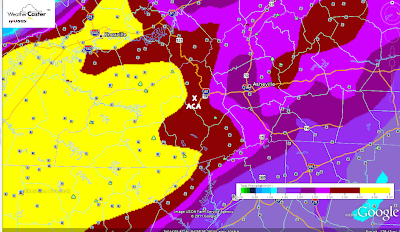
Below is this morning's run for storm totals, which is still underdone in the broad yellow zones.  ACA is the black star...pic will enlarge some if you click on it.


(UPDATE, Sunday 4pm:  Just checked my rain gauge from this afternoon's downpour, and picked up dead at 1.00" of rain....not a good harbinger of what's to come...)

Timing:  Storm chances pop up later today, but the steadier and heavier rains look to be here almost all of Monday and Tuesday ('definite' and 'likely' categories from 9am Monday through 4am Wednesday), with 'chance' category returning during the day on Wednesday, Thursday, and tailing off Friday.

No surprise a FLASH FLOOD WATCH has already been issued by the National Weather Service for our area, in effect from Monday morning through Wednesday morning.  I've got to travel out to Charlotte Monday, and am not looking forward to conditions, especially on the end of a big holiday.  Be careful out and about, y'all.  :-)

Bob

Saturday, September 3, 2011

HEAVY Rain Event heading our way

Tropical Storm Lee in the northern Gulf of Mexico will probably go down as one those tropical systems that, while minimal in wind speed and not a hurricane, will be proof in the pudding of just how destructive minimal storm systems can be.  The biggest issue is the S-L-O-W movement of this system, forecast to crawl up from Louisiana to the southern Blue Ridge....over a period of DAYS.


Normally a tropical system passing over us would mean maybe a day of heavy rain...Lee COULD provide periods of heavy rain over a 3-day period.  Starting Sunday night, scattered storms could move in, with steadier heavier rains getting in later Monday and Tuesday...and possibly hanging around 'til early Wednesday.


How much are we talking?  The map below, which you can click on to enlarge for more detail, shows up to 4"...and that's limited because this 84-hour outlook doesn't yet cover the whole rain event.  Estimates for ACA run in the 5-7" category for a storm total, which I can only hope is not surpassed.


Such torrential rains can do a whammy anywhere, and our ditches and gravel roads are expected to take a massive beating.  To think we won't have any problems in ACA would be folly, but at this time there is nothing that can be done...just be prepared for the strong potential of driving and travel issues, not just in ACA but around the region.  Too, with saturated soils and any good winds, keep in mind weaker/stressed trees will be more prone to come crashing down.


I'll certainly update the maps and numbers as I get them, so keep checking back. I will be leaving ACA Monday and back very early Wednesday to help out with weather in Charlotte.  While I would love for Lee's track to not pan out heading to north Georgia and western NC, that is the going consensus with more models coming into agreement with each run.


Bob

Friday, August 26, 2011

Of Hurricane Irene and strange critters...

I've not said anything about Hurricane Irene as it will have zero impact here at ACA  To the contrary, we'll be in the zone of subsidence and northerly breezes, and Saturday's forecast looks wonderful with highs only in the 70s.  I'm heading to Charlotte later today to help out with coverage....looks like a landfall very close to Cape Lookout (Morehead City, etc.) early Saturday (UPDATE: came ashore @ 7:30am at Cape Lookout) .  Doesn't look too good for the northeast if the track has it hugging the coast on Sunday.  Ugh.  

And now for a gratuitous dawn shot from my deck earlier this week...click to enlarge if you like...


Got a call last weekend from Linda Hughes that David had seen a bobcat walking up Staymon and not acting quite right.  Rabies is alive and well in Haywood County, and one of the tell tale signs of a rabid animal is seeing it out in the open when you rarely if ever would.  While foxes, raccoons, skunks, and bats are commonly affected, any mammal is fair game.  Haven't heard anymore about it, but I wanted to let everyone to keep an eye out for something such as this, especially for those who have dogs that roam the woods.  Too, a rabid animal can get aggressive and try to attack a human under the right circumstances.  Just good ol' FYI.

bob

Saturday, August 20, 2011

Quick note about posting comments

Al Rose brought it to my attention this morning, and it may well have been the exact same situation for Norm Jacobs that he mentioned at the annual meeting.  Because I am not one to go back and check comments that often, I'd set this blog up to notify me first of comments made for posts older than 7 days.  I'm thinking there's a glitch in the newer format and it won't let anyone comment at all on such older posts...not sure.  I have it turned off now, so posting on any entry should be possible...just no guarantee that if it's an older post it will get read.  Here is an email address for this account if you have any questions, etc. to pass along, and if I don't have an anwer I'll get it to someone who does:


applecreekacres@gmail.com


Thanks,
Bob

Friday, August 12, 2011

Road Maintenance Guidelines - New for 2011

(NOTE:  The following is a cursory yet comprehensive document for ACA road planning, the first time we've had something like this in writing.  It's a long overdue start.  Chris Martin, especially, spent many hours riding with and talking to professional road contractors, builders, and maintainers earlier this year; John Stoeckel joined him in many of these rides, as well.  Chris has since resigned from the board and is in the midst of his sojourn west, but he left this and a few other documents that he'd drawn up for us to use. Most of us would agree 'roads' are our biggest concern in ACA.

We had a great turn-out for the annual meeting last Tuesday; those minutes will be posted once they are compiled and I receive them.  If you'd like a hard copy of this report, please contact John Stoeckel, per his suggestion at the meeting.  Many thanks to Chris for his tireless work on these and other ACA road issues.)
 ____________________________________________

Road Maintenance Guidelines and Check List 
for Apple Creek Acres Road System
May 31, 2011
(compiled by Chris Martin)

 General Information from the road consultants

It takes more than one contractor to maintain the Apple Creek Road System.  The system consists not only of the paved surface (the cap) but the road base, edge, shoulder (right-of-way), culverts/drainpipes, ditches, road canopy and the gravel side roads and related shoulder, ditches, drains and canopy.  

The gravel side roads have their own unique set of maintenance issues.  Each of these road elements directly affects the overall system's health and must be maintained on a regular basis to insure passable and safe conditions. Regular maintenance also improves appearances and protects property values.

Although getting the lowest price is important, the road experts agreed that it is important to use contractors that are highly familiar with the ACA Road System and related problematic areas.   ACA's has numerous problematic areas that need to be watched and addressed each year.  These areas include Staymon road curves and drain culverts, the shoulder washing out problem adjacent the Palmer property, the spring run off adjacent the Jacobs and Foutch properties, can be reworked to reduce chronic annual repair cost.  There are other areas that need to be watched and listed.

Apple Creek Road is over 10 years old and is showing its age.  Careful planning can help off- set the aging process and protect the road against hard rains and winter.

This information was collected from discussions with the following resource people:
--------------------------------------------------- 
CONTRACTORS
           
Doug Shock, (452-5255) Villages of Plott Creek full time road manager. Doug manages approximately 23 miles of steep roads similar to Apple Creek Acres.  Doug also has 20 years experience with IPAC paving company.

Berry Anders, 400-2278, Custom Paving, Hyatt creek road for paving repair, grading, ditching w/large equipment, sweeping, curbing for water control.

David Boyd, 926-8888, mowing and right-of-way clearing.

JKC Enterprises, LLC 828-734-6998 for Roadside mowing and ditching
           
Flat concrete work, Terry Fisher 508-0863 or Dennis Queen, works with concrete  506-0192

Dennis Franklin, road concrete drains and culvert work. (unable to meet with him at time of this paper)

Manual ditch clearing, Jose Lopez, 400-6587 Call after 5pm ask for Edgar (interpreter)

Ice melt/Salt-ACE Hardware, Dellwood Rd, Waynesville, NC, Steve Carver  828-926-0300
-------------------------------------------------- 
 Ten Cardinal Rules from the Experts.

  1. The main question to ask is what does the ACAHA want the AC Road System to look like in 8 to 10 years?   What will this cost annually?  How does the association keep cost down and ward against inflation while trying to achieve the 8-10 year goal. 
  1. Supervise contractors while they are working.  Make sure an ACAHA board member or representative is on hand supervise and take notes.  Contractors appreciate being accompanied by a member of the association's board.  This saves money, time and is a good learning process for the association. There are times when contractors make mistakes.  If spotted early the contractor is willing to correct the problem.  Don't wait until people start to complain.  It's usually too late by then.
  1. Get the water off the road, into ditches as soon as possible.  One expert, while driving on Apple Creek road during a heavy rain observed "that water is staying on this road too long."  Run off water gathers momentum and cuts and destroys road surfaces, shoulders and clogs drains.  In winter water carries damaging salt/ice melt to weak road sections causing further damage.
  1. Keep the road edge clear of obstructions like leaves, grass, and other water routing debris.  Water cannot drain from the road to the appropriate ditch if the road edge is blocked.  Water will stay on the road to gather momentum and cause problems.  This will increase road maintenance cost.
  1. Keep road right-of-way clear.  Keep shoulders and ditches free of foliage, small trees, sticks and rocks.  Removing small trees or saplings will reduce mowing cost.   A mower should have clear passage all the way to the top.  This also includes side roads.
  1. Keep the sun on the road. Trim trees and tree limbs that hang over the road creating a thick canopy that blocks the sun. Shade keeps roads wet and frozen.  Thaw-freeze causes serious road damage.  Tree limbs and trunks, even in winter, shade the road and significantly reduces sunlight and melting.
  1. Keep all drains clear including driveway drains.  Driveway drains are directly related to the overall drainage system in Apple Creek Acres and serves to protect the road investment.  Ask neighbors to report problems with their driveway drains and water runoff along their property right-of-ways.
  1. "Check dams" made properly from Rip-Rap in ditches in steep areas can serve to reduce water momentum.  These dams must be cleared of leaves, sticks and other matter each year.
  1. "Watch for "heaving".  A road is not all about the top or paved cap.  The base is more important.  If the base is damaged the cap will simply slide off the top.  Watch for evidence of "heaving" where the pavement appears to be oozing or sliding off the surface of the road.  This area must be dug up, the base replaced and the cap repaved.  Salt getting in the base can also cause heaving.  Never use salt on gravel roads!  This will destroy the road's base.
  1. Keep gravel side roads graded at such an angle that water will run off into the appropriate ditch, drain and culvert.  Water remaining on gravel roads will cause rutting and washing.  Capping the curves of steep gravel roads is recommended
--------------------------------------------------------------
Road Maintenance Timetable and Checklist

Oct-Dec     Do preliminary inspection of the road system with contractor to determine areas for repair and determine estimated cost so budget can be approved and fees set for December mail out.

Nov-Dec     Mowing after first frost to remove remaining summer stubble and brush to clear ditches for cleaning and improve visibility. Clear ditches and drains in preparation winter rain and snow run off.
                       
Feb-March    Contact and meet with road contactors to inspect for road repairs and maintenance and over winter damage.  Check problematic areas such as Staymon ditches and drains.  Get cost estimates and adjust budget.
                       
April-June    Road repairs and maintenance start. Person to supervise contractors and keep president and board updated
           
June-July     Summer mowing begins.  Inspect ditches and drains after mowing.

July-Aug     Further maintenance and follow up report for Annual Meeting.  Prepare for ACAHA Annual Meeting.

-----------------------------------------------
Winter Road Conditions Guidelines for Apple Creek Acres

The ACAHA snow and Ice removal efforts are governed by the weather and available budget funds.  Best efforts are taken to make the road passable as soon as possible.  Be prepared.  Know your limitations and strengths and think carefully and please use the Apple Creek Blog to stay informed.  Remember, road conditions along the length of Apple Creek Road vary considerably.

Ice should be on hand for the snow removal contractor and road-side boxes filled before December 1 since snows appear to be arriving earlier.  There is an open charge account at ACE Hardware.  A letter establishing this letter may need to be renewed if ACE Hardware is the supplier.

  1. Check the ACA blog site at http://applecreekacres.blogspot.com for any updated weather and driving conditions along Apple Creek.  Last winter, Claire Stoeckel used to blog to post any information she had on estimated salting/plowing times, etc.
  2. Generally, snow plowing will begin after much of the predicted snow has fallen unless super heavy snows are predicted.
  3. Do not abandon your vehicle in Apple Creek Road.  This will stop plowing efforts.  Your vehicle may be seriously damaged as cars attempt to move down the road.
  4. If unable to move forward pull or back into a ditch along the right of way. 
  5. With permission park in drives, side roads and along Mauney Cove road and walk.
  6. Call your neighbors about road conditions along Apple Creek road before you leave home.   If driving in form the outside call someone before going up the mountain.  Keep the phone list with you.  Make copies.
  7. Stay with others who live lower on the mountain or in town.
  8. Ask yourself how suitable your car or driving ability is for driving on a steep snowy/icy mountain road.
  9. Carry several bags of salt or sand in your car preferably over the rear axle.
  10. Carry extra cloths, shoes, blankets, food, flashlight and medications
  11. Get some Yak-Tracks for shoes at Mast Store in town. 
  12. Have enough food, water and medications in your home for a week.
  13. During icy conditions expect power outages.
  14. Keep a battery operated weather radio handy in home and car.
  15. Have a close neighbor check on you during heavy snows.  Do the same for them.
  16. Make prior arrangements for your pets in case you are snowed out of ACA.
  17. Remember you have to go up the mountain at the end of the day.  The road starts to refreeze after 3 pm.  Try to be home before then.  If possible try to leave after 10 am and return before 3 pm.
  18. Freezing occurs rapidly at the "Blue Roof House" (Moskos) location and above.
  19. Vehicles moving down the road will usually take the right-of- away to maintain control.
  20. Avoid inviting friends and family during icy conditions.  They are most prone to be stuck or hurt.
     -------------------------------------------

    (Bob Child)