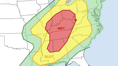
(Sun a.m. updates in RED)
Wow. Not just a word for here in ACA but simply the far-reaching devastation of this last storm system. While the winds at my house in ACA were worse Wednesday night than last night, it was still a mess-maker and a home-wrecker here. Before I get to the snow discussion, passing on some preliminary facts that I, as a meteorologist, find jaw-dropping:
Wow. Not just a word for here in ACA but simply the far-reaching devastation of this last storm system. While the winds at my house in ACA were worse Wednesday night than last night, it was still a mess-maker and a home-wrecker here. Before I get to the snow discussion, passing on some preliminary facts that I, as a meteorologist, find jaw-dropping:
In all of February in the U.S., 189 tornado warnings were issued. For March, by 10p Friday night (3/2), the National Weather Service had already issued 269 tornado warnings.
Preliminary count for 'severe' storm reports made to the Storm Prediction Center in Norman, OK for Friday 3/2 (these numbers will be adjusted later today):
101 tornado reports
281 hail reports
442 wind reports
(824 TOTAL reports)
Below are two radar grabs I made of the late-morning tornadoes kicking up in northern AL...the tornado shafts are the semi-cylindrical shapes trailing off the edge of the storms (click to enlarge):
Below are two radar grabs I made of the late-morning tornadoes kicking up in northern AL...the tornado shafts are the semi-cylindrical shapes trailing off the edge of the storms (click to enlarge):
 |
| FUNNEL NEAR HARVEST, AL ~11am 3/2/12 |
 |
| FUNNEL NEAR NEW MARKET, AL ~11:10am 3/2/12 |
Now to the talk of SNOW. A flurry here, there, and yon is possible later this evening...any incoming clouds early this morning are truly flying under the radar beam as what light snow I saw fall early this morning was not on the radar. Looks like from about midnight Sunday through the morning commute Monday there will be a stronger push of moisture and chance for light accumulating snow here. Both the NAM and GFS are currently painting a dusting to 2" in the higher elevations.
HOWEVER....winds are supposed to continuing to be pretty gusty even overnight, which always helps to limit any accumulations. I'm heading out of town today, so I won't be here to see things for myself, should something fall; just use your good ol' common mountain sense as you head out in the morning in case there are any icy/slick spots, especially on curves.
HOWEVER....winds are supposed to continuing to be pretty gusty even overnight, which always helps to limit any accumulations. I'm heading out of town today, so I won't be here to see things for myself, should something fall; just use your good ol' common mountain sense as you head out in the morning in case there are any icy/slick spots, especially on curves.
Bob

