Thursday, January 12, 2023

WINTER WEATHER UPDATE

 So much for promising a time and failing to get a post up!  Apologies...

As is usually the case, we can split ACA into the upper and lower halves, delineated by the blue roof house at Dawen Circle.

Upper:  A Winter Storm Warning is in effect from MIDNIGHT TONIGHT through 7am SATURDAY.  What looked like very limited moisture must have more than forecast as the potential amounts have increased some.  For upper ACA, 1.5"-3.5" seems plausible...anticipated winds could limit the high end, however.

Lower:  A Winter Weather Advisory is in effect for elevations below 3500'.  Same time frame, but with lesser amounts, in the 0.75" to 1.75" range.

Winds:  starting with this afternoon's storms I hear growling away to the west, wind gusts through this whole event could gust to 40mph.  The potential for power outages goes without saying...a tree feel across the road just below the double hairpin curves before sunrise, and there was nothing going on weather-wise.  Trees can easily come down, so just be prepared.  Yesterday at 2pm, when all was quiet, a massive thundering crash came from a dead tree hitting another dead tree, somewhere just on the downhill side of Tannehill Lane.  Third time's the charm...

Temperatures:  Wind chills Friday and Friday night could easily get into the single digits.  The saving grace is that we won't see below zero temperatures from this system; suffice it to say we're in for a couple of cold, wintry days before we round a bend.

I'm on the mountain all day and night Friday, so I'll update as needed and helpful.  Here we go!...


Bob

Tuesday, January 10, 2023

A WEATHER 'HEADS UP'...

FROM MY FILES: Barn Swallow by Lake J dam

(Thursday AM quick note:  I will post a full update around 1:00pm or shortly thereafter once I return home.  Today's thunderstorm chances have increased...look for a bit of a windy squall-like line to hit this afternoon.)

We are certainly well underway for the latest first snow of the season that I can remember in ACA, but this incoming scenario is not a slam dunk by any means.  Just wanted to share the end-of-week weather ahead.

Thursday will be windy and (relatively) mild as southwest winds whip out ahead of a strong cold front.  It will bring some rain chances not only in the form of showers but also some isolated thunderstorms Thursday afternoon and evening.  

There will still be some moisture to move through from the W/NW after the temperatures start rapidly falling Thursday night.  Light snow may start around 3-4am, with daybreak lows in the upper 20s.  Highs Friday will only be in the 30s, so especially for elevations above 3500' snow showers may well continue into Friday night.  Any lingering moisture will wrap up well before sunrise Saturday, with lows dropping into the 17-22 degree range.  

The NWS will post advisories and such Thursday...models indicate <1" for Waynesville and Lake Junaluska, with 0.5-2" possible above 3500' in ACA.  The spine of the Smokies could get 4-6", with amounts tailing off fairly quickly as you move SE of the TN border.  

As always, stay tuned...


Bob

Saturday, December 24, 2022

CHRISTMAS EVE...

Apparently the snow-over-ice issue was mostly above the double-hairpin curve.  I finally got my driveway in useable shape to head into town on errands Friday, though Staymon Road is slippery. I've only gotten down to -6 degrees this morning, so not the coldest I've seen over the years....but suffice it to say I'm glad the wind isn't blowing any harder now!

Speaking of wind, for those that like numbers, click HERE to read the ranked NWS reports of maximum winds in the GSP forecast area.  I was surprised that I kept power on, though some Duke Energy trucks did travel above Staymon Road, so someone must have had a power issue (hopefully short-lived).

Thankfully there is no other precipitation forecast while we are in the deep freeze.  The wind advisories peter out Christmas morning, and it looks like most of us in ACA will go above 32 degrees Monday.  By Thursday and Friday, highs will be in the mid 50s to around 60, so keep the faith.  All will be sunny and dry through the week.

Whatever and however you celebrate this season, I wish everyone good health (not easily come by these days) and safe times.  I'll leave you with one of my favorite videos and songs:  The Platters singing "White Christmas"...

Click HERE


Bob

Thursday, December 22, 2022

BITTER COLD, WIND, AND A KISS OF SNOW....

3:30am Friday:  Everything below stands.  It transitioned from rain to heavy sleet around 230am to snow.  NOT a good situation as that means below any white will be ice.  Temp just dropped from 32 to 29 in just a few minutes.  Wind is the strongest I've seen/heard in a long time, already with a loud noise on the roof from part of a tree.  And so begins Mr. Toad's Wild Ride....

(I'll get to the incoming, serious weather in a moment. I made a 5:30pm update at the bottom)... 

I decided to go to Lake J yesterday to hopefully add a Bufflehead to my Bucket List of ducks.  Quite often, Buffies are waaaaay out in the middle of the lake, out of my camera range.  On rare occasion I've seen them closer to shore...alas, they did not cooperate.  However....I feel kind of stupid that I'd never realized there were Double-crested Cormorants at the lake, which I first saw a couple of weeks ago.  In well over 10 years I've never seen them, or simply overlooked 'em.  So I first present you with a handsome one (click to enlarge):

Double-crested Cormorant at Lake Junaluska

For the past 3 years (and now 4 after Christmas), Lake Junaluska has been drained mainly to dredge the upper basin.  It has put a whammy on the Atlantic Flyway migrations here as the species and numbers have plummeted, sadly, as they go elsewhere.  However, there are always a few who hang around, and I got to enjoy photographing Ring-necked Ducks in several locations.  They're diving ducks, so it's like playing Whack-A-Mole as to when and where they pop back up. In no particular order are a few shots of mostly drakes with a couple of hens joining in (as with any pics on here, click to enlarge) :


Ring-necked drake coming up from a dive


(We now return to the regularly scheduled forecast:)

They say a picture paints a thousand words...start writing...:

Click to enlarge

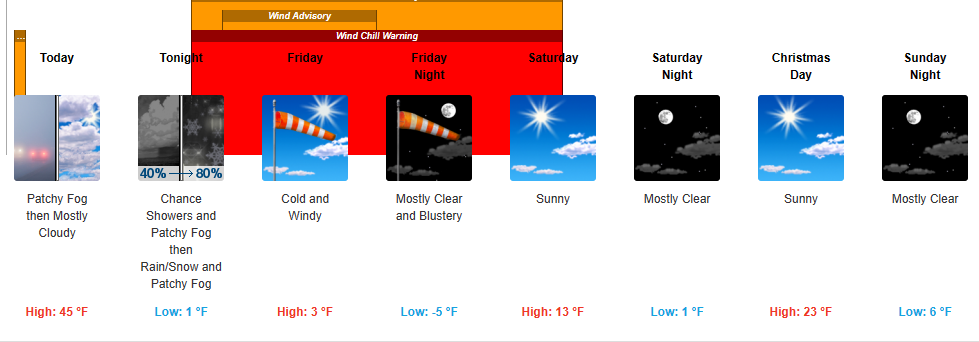
Enjoy what relative warmth we have today through tonight.  Around 3am or so is when we fall into the Rabbit Hole.  First, prepare for power outages.  Charge batteries, have flashlights and candles ready, and whatever you need to stay warm.  The wind is forecast to be very gusty and strong as the cold front passes through and well behind it. Downed trees are quite possible. The temperatures will plummet very quickly with the passage, and wind chills here in ACA will most likely run from -10 to -20 degrees.  The numbers above tell the story...coldest highs I will have seen in my time here in ACA.  The coldest morning I've recorded was -9 degrees many years ago, and I may well give that a run for the money.  Friday is a brutal, brutal day.

Insofar as the official NWS notifications, click HERE for all the advisories (new link as of 5:30pm).  Interestingly, none of the advisories talk about precipitation, only winds, temperatures, and wind chills.  There simply are too many variations to try and list them here...suffice it to say it will be dangerously cold, potentially slippery, and wind chills that will make you think you're at the Arctic Circle.

*UPDATE* This is the updated addendum.  It warmed up nicely today, so the roads have some added energy that may help at the onset of precipitation and dropping temps.  In short order, that benefit will go bye-bye, but we'll take any gift we can get.

Precipitation will begin as light rain around 10pm.  Switchover to light snow should be around 12am-2am.  The amount of snow remains at a dusting to 1" on the topside, higher toward the TN border.  It looks like the snow will move in from the west, not the northwest, which means the Smokies block a good bit of our intended moisture.

Keep in mind, with the crashing cold...what sticks stays, and road salt will do absolutely nothing as it will be well below workable range.  If you have the sub-zero salts from Walmart, Lowe's, etc., they should work on your driveway; I'm talking about the road salt our plower/salter uses.  Precipitation should be a done deal before sunrise.

Wind and cold, wind and cold...and hopefully no power outages.


Bob

Wednesday, December 21, 2022

WINTER WEATHER ADVISORY TONIGHT

5:50am UPDATE:  My gauges are at 32 and 33 degrees.  No icing here at the end of Staymon on vegetation, deck, etc.  The BIG story next is wind and cold, along with light frozen precipitation Thursday night into early Friday morning.  I'll post more on that later this morning.

-----------------------------------------------

This is most likely Part 1 of II in terms of winter weather notifications.  The second part will be for Thursday night into at least Friday.

Tonight:  ACA is in a Winter Weather Advisory from 7pm until 9am for accumulating freezing rain, basically above 3500' elevation (above the blue roof house).  Should it begin accumulating on the roads, then serious travel issues are likely until it switches to all rain Thursday (for a while).  

This is a situation that is more likely as you approach the southern escarpment of the Blue Ridge, and almost a non-issue the closer you get to the TN border.  In that sense we may be spared here in ACA.  As is always the case in icing events, the first sign is icing on vegetation, followed by icing on cars, decks, stairs.  Roads are the last to succumb to ice.

I will be on the mountain the whole time, so will update as needed.

Thursday night into Friday morning is when the Part II should show up, which is the rapidly crashing temperatures with (limited) back-side snow.  Oftentimes when we have rain, then the cold and snow, there is a period of no precipitation and evaporation takes place in the cold dry air, avoiding an icy base.  I'm not convinced we'll have that luxury, late tomorrow.

Why so little snow to come? (heavy dusting to MAYbe an inch)  The jet stream will have stayed too long on the west side of the Appalachians.  We'll get the bitter cold, but there will be little moisture to work with, and the ensuing northwest flow wrapping around the Great Lakes low pressure looks to have little moisture for us.  

BUT...the caveat, especially with anything icy....it takes very little to send a car off a road.  I'll post more on tomorrow night tomorrow when the National Weather Service updates the forecast concerns.


Bob

Saturday, December 17, 2022

CHILLY WEEKEND....BUT JUST WAIT...

For various reasons, I've not been firing my cameras recently, so I figured I'd pull one from the vault.  This was taken many years ago at Lake Junaluska, a Green Heron looking for a meal.  Click to enlarge.

Aside from the one multi-day cold snap recently, the weather has been agreeable in terms of temperatures and lack of frozen stuff (I'm ignoring the gray and rainy days as we needed the rain!).  Looks like a pretty cold but sunny weekend with lows in the teens (Sun-Mon) for some of us and highs that may barely reach 30 degrees for those that stay in the shade.

Late next week, and the reason for my post, is that a very strong cold front looks to pass through next Thursday and crash our Friday morning lows into the single digits, possibly.  Along with that should be a strong northwest flow, but one with more limited moisture.  

Any rain Thursday will most likely switch over to light snow, and depending on how the timing works out it could be a bit icy Friday morning.  At this time snow chances are limited and the EURO model paints a total of less than 0.5" of snow from Thursday night into Saturday.  A good solid kiss of winter without hampering travel

This is all pretty far out (read 'take it with a grain of salt'), but I haven't posted in a good while and thought this might be of interest.


Bob

Thursday, November 24, 2022

HAPPY THANKSGIVING, ALL Y'ALL!


Golden sunrise from a couple of weeks ago, from home on Staymon Road. (click to enlarge)