Saturday, June 18, 2011

HEADS UP: Saturday afternoon

While ACA is under a SEVERE THUNDERSTORM WATCH until 6pm, I'm concerned with what is not too far away:  another bow-line echo of storms akin to what we had hit Wednesday.  Severe cells are bad enough, but when they are coalesced into a bowing line covering many many miles, they are almost always notorious wind producers, much less the hail and all we had Wednesday.
SATURDAY @ 1pm

The second concern is that with our northern exposure, we are in line to take a more direct hit again, just like Wednesday.  All this to say that if you get this soon after I post this, batten down your hatches!

Below is a short video clip of what happened when I didn't time my chicken right Wednesday!  Thought I could beat the storm, but that bow line was moving too fast for me and, well,....I didn't let that chicken marinate for 24 hours for nuthin'!  Need to get a grilling helmet.....


Thursday, May 26, 2011

MUSICAL STORMS

Combining two notices, here, FYI....UPDATES in green.

Up first is our Severe Thunderstorm Watch until 6 pm.  This is the remnant of this week's heavily tornadic system that is now creating thin, powerful storm lines oriented SW to NE, currently in east TN.  The eastward movement is slow, and the mainly NNE movement of the storms means once again the Smokies and the Plott Balsams will help break up a lot of the intensity.  Heck, as far as that goes, ACA is on the north side of the ridge, which is protective as well. With that said, a warning on an active cell coming from Hayesville directly toward Waynesville is packing half-dollar sized hail and 60 mph winds, fyi (@ 3:52pm).

Damaging winds and large hail are the main concerns of this system.  Modeling suggests the 'likely' time frame for the strongest storms would be 3p through 10p later today....and while rain and storm chances continue through Friday, tonight's activity is the immediate concern.  

I'm down in Charlotte forecasting, so if there are ACA issues, damage, etc., please enter your information in the 'comment' section below.

---------------------------------------- 

Right on cue for the calmer weekend, ACA's own Lorraine Conard and her band cohorts will be playing at the Haywood Historic Farmer's Market - Memorial Day Weekend Party from 10am to 2:30pm (Market hours are 8a to 1p).

Neat 'happening', that market.  Just take 276 a tad south of downtown Waynesville, and you'll see the HART Theater parking area on the right, and all the festivities just beyond.  Worth the trip.  Sorry I can't be there!

Bob
Wednesday, April 27, 2011

STRONG STORMS TODAY/TONIGHT

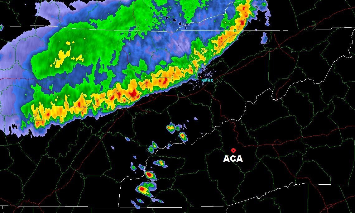
Chances for severe storms here in ACA the next 18 hours or so have heightened rather noticeably.  While storms are possible anytime today, the most likely window for damaging storms will be from 6p through 3am.  A tornado watch already exists up to the NC border in north GA, and I fully expect us to be under one later today.  It is going to be a very damaging day for areas in the Southeast, again, sadly.

8A WED through 8A THU (click to enlarge)

I have to adjust my travel plans today because of the weather, so won't be here should there be any ACA problems/updates....you can send info via the comments section or contact Chris Martin or John Stoeckel, as always.


Bob

Tuesday, April 26, 2011

Severe storms possible WEDNESDAY


Yet another round of headline-making stormy weather is forecast around us Wednesday.  We're borderline from being in a "moderate" risk for severe storms, which is not a good thing,  Winds, however, will be south-southwest, and I'm assuming storms will travel in like manner.  That makes us in ACA a little more protected, with much heavier rainfall expected south/southeast of the Blue Ridge Parkway where the uplifting air will wring itself out on the southern Blue Ridge. 

For severe cells to affect us, the storms will have to traverse a lot of mountainous terrain to the SW, which again works in our favor to keep severe potential limited for us in ACA.  Be that as it may, I expect us to come under a Watch box sometime Wednesday.  Rotating cells are possible if not likely, as well, and damaging winds/tornadoes are the feared component.  Likely timeframe for the worst of the worst is Wednesday night, though storms possible anytime during the day.

Just a good ol' heads up.  Anticipated road work in ACA may well be hampered by the weather, as it has been already.

Bob

Saturday, April 23, 2011

ROAD WORK: APRIL 25-26

Due to the inclement weather the past few days, as well as this weekend's holiday, road work will resume along Apple Creek Road and Staymon Road April 25 and 26 (Monday and Tuesday).  Please be aware of slow moving, heavy equipment as you drive.
 
Contact Chris Martin for more information 400-9754

Thursday, April 21, 2011

ROAD WORK THURSDAY/FRIDAY

CAUTION!
THERE WILL BE HEAVY EQUIPMENT AND  ROAD WORK 

ALONG APPLE CREEK AND STAYMOND ROAD APRIL 21-22
 
Contact Chris Martin for more information 400-9754

Tuesday, April 19, 2011

Wednesday Weather and Tornado Map

Heads up for another round of mid-day storms with attitudes Wednesday. Storm Prediction Center has ACA in the "Slight" risk category for storms at 'severe' limits.  The 'likely' window in digital modeling is from 11a til 4pm, and the main threat would be damaging straight line winds.  But, as I always say, direct lightning hits I fear worst.  ;-)  Not anticipating rotating (tornadic) cells with this one.

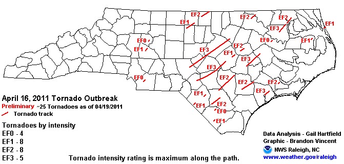
I still muse how fortunate we (ACA) were from the last system Fri/Sat.  We got the rain but not the storms, unlike the eastern half of North Carolina.  We've seen the damage pictures and heard the stories, but here is a map from the Raleigh Weather Service showing the Saturday tornado tracks and strengths, for those interested.

(click image to enlarge)
 
 
Going back a couple of strong storm systems before that, where those at least higher up in ACA got snow on the backside, strong winds brought down a good many trees here.  At my house, there was no damage...a lightweight snow shovel leaned up against the house and bird feeders just feet away all stayed in place with the strong winds.  However, I discovered the lid to the hot tub cover had been speared by a lichen covered tree limb, which not only stuck in the lid but penetrated over 3 inches through the other side.  I cannot imagine the wind force it took to jettison that blunted dead stick so forcefully as it did. Eeegads.