Heads up for another round of mid-day storms with attitudes Wednesday. Storm Prediction Center has ACA in the "Slight" risk category for storms at 'severe' limits. The 'likely' window in digital modeling is from 11a til 4pm, and the main threat would be damaging straight line winds. But, as I always say, direct lightning hits I fear worst. ;-) Not anticipating rotating (tornadic) cells with this one.
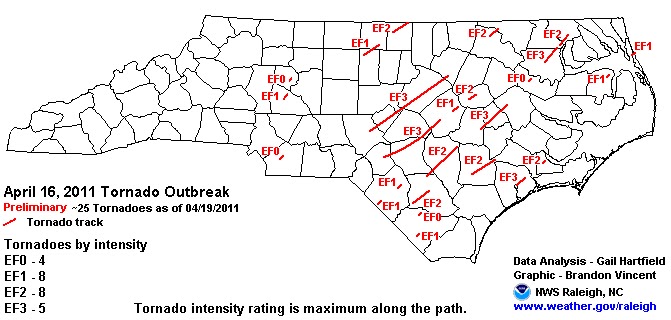
I still muse how fortunate we (ACA) were from the last system Fri/Sat. We got the rain but not the storms, unlike the eastern half of North Carolina. We've seen the damage pictures and heard the stories, but here is a map from the Raleigh Weather Service showing the Saturday tornado tracks and strengths, for those interested.
(click image to enlarge)
Going back a couple of strong storm systems before that, where those at least higher up in ACA got snow on the backside, strong winds brought down a good many trees here. At my house, there was no damage...a lightweight snow shovel leaned up against the house and bird feeders just feet away all stayed in place with the strong winds. However, I discovered the lid to the hot tub cover had been speared by a lichen covered tree limb, which not only stuck in the lid but penetrated over 3 inches through the other side. I cannot imagine the wind force it took to jettison that blunted dead stick so forcefully as it did. Eeegads.


No comments:
Post a Comment