Wednesday, December 18, 2019

SALT BOX USEAGE POLICY

Brrrr.  Imagine the snow we would have if all the moisture met up with these cold temps!

You've noticed the myriad plastic storage boxes along Apple Creek Road, labeled accordingly with HOA symbols.  These are salt boxes provided by the board in cases of ICING emergencies for given trouble spots.  The ACAHOA board wanted me to post the policy concerning use of those boxes:
---------------------------------

PLEASE, reattach lids to salt boxes!

 *  Unattached lids will blow away 
 *  Open boxes will accumulate moisture causing ice melt to clump
  
The HOA will attempt to keep two bags of ice melt in each salt box.  This is enough for two icing events.  Please use only one bag of ice melt from each box per event.

No ice melt on gravel roads.

When the contractor has been here and salted the road, please do not add more.

Pre-salting of the road may only be done by the HOA contractor.

HOA volunteers would greatly appreciate your disposing of empty bags.
                                                                                               Thank you

--------------------------------------

Bob

Thursday, December 12, 2019

JUST A COLD RAIN...

For locations east and south of Haywood County, there is a Winter Weather Advisory for freezing rain the early part of Friday. It looks like we will just dodge the issue by a degree or two, which is fine by me. Ice is the Great Equalizer… I'll drive all day in several inches of snow but a quarter inch of ice and nobody goes anywhere. Looks like it won't be an issue until you get to the Southern edge of the Blue Ridge escarpment and points East into the foothills, should your travels take you that way.


Bob

Wednesday, December 11, 2019

A FEW ICY SPOTS...

I picked up 0.75" of snow on top of an icy bottom last night, but the driveway was only partially covered...nothing a little salt couldn't handle.

There are a few slick spots on Apple Creek Road at and above the double hairpins, so just a heads up for that. Otherwise, it's a bright and beautiful day. πŸ™‚

Tuesday, December 10, 2019

NEW PLOWING INFORMATION: SAVE

I just revised tonight's forecast in a prior post a few minutes ago...meant to post this, as well.  PLEASE save/bookmark this page and label it accordingly to help out when we do get a decent snowfall here in ACA.

-----------------------------------------------------

The HOA has contracted with a new snow plow operator who will be available to do driveways after he has completed the main roads. 

His name is Nathan Franklin and his number is 828-788-1464. Mr. Franklin has requested that individuals wanting driveways done please leave him voicemail and he will call them.

--------------------------------------------------------

Bob

UPDATE: MINOR WINTER WEATHER HIT

As I type at 430pm, Haywood County is under a Winter Weather Advisory, (click link) but not really for ACA, even though we have elevations above 3500'.  The very latest indications are good snows for eastern TN up to and within 10 miles of the TN border, but once again, we stand for a dusting/icing of very little.  One of those "close, but no cigar" type of situations as the cold air does not manifest here before the precipitation ends, basically.  A dusting, at best.  Both the 'filtered' NAM and GFS have pulled back to 0-1" for what's to come, and it makes sense.

I have no reason to expect travel difficulties in the morning.  The school system MIGHT as Fines Creek is a litmus test, and they may pick up sleet/snow of 1+" by daybreak, but truth be told it looks like we are dodging yet another snowy system.


Bob

Tuesday, December 3, 2019

WEATHER/ROAD UPDATE

TUESDAY 7AM (end of Staymon Rd)

Good snowy morning everyone...well, really for those above the 3500' level at the blue roof house. We picked up a heavy coating of snow that has covered all surfaces, including the roads. It could be little slick for a while so please use caution heading down this morning. There are no road issues below 3500'.

Overall, this basically non-event dropped 0.2" of powdery snow. Thankfully, I captured the first round of snow for prosperity's sake...

SNOWMAGEDDON 11/30-12/1/19

Bob

Monday, December 2, 2019

50/50 ...

I feel bad that after all these years I didn't have the guts to side with my 0 to 1 inch models which unwaveringly held for 24 straight model runs. However, the NWS warning/advisory has been verifying not too far from us to the North and especially along the Tennessee border where they are getting significantly more snow. I saw a car at Food Lion that had a couple of inches on it that came down from Crabtree.

 While the warnings and advisories continue until 7 o'clock in the morning, the radar echoes are pretty empty and I don't think ACA will see anything more than the few flakes flying around like we've been seeing this morning. Temps start moderating tomorrow, as well.

Happy December, y'all!


Bob

Sunday, December 1, 2019

UPGRADE: WINTER STORM WARNING

For elevations above 3500', the Winter Weather Advisory has been upgraded to a Winter Storm Warning (click on link).  Basically, that means a vote of confidence from the National Weather Service (NWS) for the higher accumulations I spoke of in the prior post.

 Truth be told, the forecast amounts per the warning are even higher. It still stands to reason the highest accumulations will be on the Tennessee border. However, the NWS is upping the potential snowfall, even for Waynesville, to 4 to 5" down low and 5 to 10" above 3500'. Seems high to me, but I defer to caution. Do my favored interpolated models see anything new, now? No. Still 0-1".  Hmmm...

As I type a little after 11:00 p.m. tonight, the temperature is 36゚ and the snow, at least by the radar, is falling above us toward Fines Creek. I will be updating early in the morning once I see what is happening.

Bob


WINTER WEATHER ADVISORY

Good Sunday morning, everybody. We now have a Winter weather advisory (click on link) for Haywood County in effect from 7:00 p.m. tonight through 7am Tuesday.

 This incoming snow situation is a bit different than any I've seen in many years. Pretty heavy accumulations will occur along the Tennessee border and maybe 5 to 10 miles from it before there is a sharp drop off in accumulations. My models still show ACA in the 0 to 1" category; however, the advisory is saying 1 to 2" in the lower elevations and for our upper elevations that could be from 2 to 4". It's best to defer to the NWS and be prepared for their projections. I'll be curious about totals as not one single model run of the GFS and NAM the past couple of days has had ACA in more than the 1 inch category.

 This morning's rain showers will soon end, and the Sun should return for another mild day. The temperatures start to drop tonight with a cold front with the snow setting in after dark but mostly in the overnight hours. Northwest flow events can continue for more than a day, and accumulations can be a real wild card. Thankfully, we've got a nice day to prepare for this roll of the weather dice.


Bob


Saturday, November 30, 2019

A BIT OF SNOW FOR ACA...

There is no doubt we have been totally spoiled by our mild temperatures lately. While there is a big shot of cold air that will be in place late Sunday night through Monday, the ground should be warm enough to limit accumulations on road surfaces. Be that as it may, it doesn't take much to make for dangerously slick roads on our mountain.

 This will be another Northwest flow event, that looks to drop 2 to 4" along the Tennessee border near us. As you go up towards Roan Mountain and northeast of they are, they may see as much as 6 to possibly 8" of snow. The odd thing is, my favored models don't show much of that snow getting down to central Haywood County, with ACA in the dusting to 1" category.

 As I am writing this about 6:30 p.m Saturday., there are no winter weather advisories, watches, or warnings for Western North Carolina… yet.  The switch over to snow showers should take place approximate to midnight Sunday night and last through a good bit of Monday. Temperatures will definitely be much colder, in the 30s, and if the snow overrides the warm ground, the roads may well be slick early Monday morning. I will post an update sometime Sunday when I see more specific information.

Bob

Tuesday, November 12, 2019

SNOW UPDATE

The temperature has dropped to 28゚at the end of Staymon Road, and the ground and my driveway are all white. Because there was some rain early on, the belly of this snow may well be going to ice very quickly, so be extremely careful if you must travel the mountain.

 The snow machine has come to an end for round one, but the reason the advisory goes until 7:00 in the morning Wednesday is that the National Weather Service is anticipating the northwest flow showers to continue off and on. At the moment, they seem to be relegated to the Tennessee border, but not here...for now.

Feel free to add pertinent road information in the comments below.

Monday, November 11, 2019

HELLO, FIRST SHOT OF WINTER!

Ah, 'tis the season, eh?  While all the long-term forecasts point to a mild-ish winter, there will always be shots of arctic air and snows, regardless.  Incoming tonight is our first solid chance of bitter cold and snow, albeit light amounts overall.

We've got a fair number of new residents in Apple Creek, so others forgive me for my repetitive remarks.  Give me 2-4 inches of snow and I'll drive up and down Apple Creek in 4WD without too much trouble.  Give me 0.25" or 1/2", and I might not make it.  With the thin layer, wheels will compact the snow to ice quickly, and nobody can negotiate icy roads. We have some deceivingly steep sections here and there, so always TAKE YOUR TIME AND GO SLOWLY.  2WD, even if FWD, has a poor success rating on our roads when 'white'.

From our mild temps even as I type at 430pm, they will crash well before sunrise to near/below freezing....and perfectly timed with the incoming precipitation with the cold front.  IF it starts as liquid, it will quickly transition to snow, and temperatures will more than likey hold steady at daybreak and then fall through the afternoon and night down into the teens for Wednesday morning.  Roads will deteriorate tomorrow morning as there will be no opportunity for melting until some Wednesday afternoon.  Here's the scoop...

Per the National Weather Service (NWS), ACA is under a WINTER WEATHER ADVISORY (click for link) from 4am Tuesday through 7am Wednesday. The Advisory is for 1-2" in the valleys and 2-4" above 3500'. ACA's 3500' mark is the "blue roof house", and it is a crazy but accurate demarcation point in many of our snows.  This will be a "northwest flow event" that will be highly dependent on the moisture flow lines per accumulations.  If it's more WNW, amounts cut back for us; if it's true NW or NNW, we can pick up more than expected.  I'll be updating in the morning as I should be back on the mountain by 3am, crossing fingers.

I'm siding with my GFS model which is more towards 1" in the valley and 2" to a borderline 3" if not here then very close to ACA.  Regardless, temps crash, some snow falls and sticks on roads, and we hunker down for a VERY cold Tuesday.  Haywood County Schools will have an interesting call to make...a 10am early dismissal may be too late for roads in the northern part of the county, so I'm anticipating either a 'delay' to be followed by cancelation, or an outright cancelation by daybreak.

More than likely, I'll put up a new post in the morning once I see what's upon us.

Bob


Thursday, October 31, 2019

TOO MUCH OF A GOOD THING...

Talk about going from feast to famine…or rather, from famine to feast.  The onslaught of rain this week, heavy at times, has done a whammy on doing some gravel road erosion but also in knocking leaves off of the trees. It was bound to happen as dry as we were before. With this heavy rain falling the coating of leaves on our roads is pretty impressive, and not in a good way. The temperatures are supposed to plummet to night below freezing and although the dryer frigid air may evaporate a lot of the liquid, I well imagine some areas will be icy-slippery early in the morning. Please use caution and take care if you are heading down early in the day, like many of us are here up on the mountain.

 If there is any pertinent information to update with, I'll put it on early in the morning. Tis the season…!

Friday, August 30, 2019

PAVING UPDATE!!!

Word just came in and that paving is to be starting this coming Tuesday after Monday, Labor Day. If there are any changes or additional information, I'll post them in a timely manner here. As always, there will be signs posted down at the entrance to Apple Creek Acres, as well.

Bob


Tuesday, August 27, 2019

HOA UPDATE: SAVE FOR CONTACTS

Passing on information on our new HOA board; please bookmark for future reference.
‐----------------------------

New officers and their contact information:

President
Jeff Hintzman jeffhintzman@att.net

Vice President for Roads
Keith Patton 456-8895

Vice President for Administration
Lauren Roth lrothwell7@gmail.com

Treasurer
Carrie Patton carriescollier@yahoo.com

Secretary
Melinda Owens melindaowens40@gmail.com

*The HOA has received numerous complaints about speeding on our roads. We request that everyone abide by the 15 MPH limit.

*Bear Hunting and the poaching of Ginseng are illegal in Apple Creek Acres. Anyone who observes these activities or strange vehicles parked on our roads is asked to call the Haywood County Sheriffs Department 452-6666.

* Winter is coming and we would like to remind all residents that salt may not be used on gravel roads.
----------------------------

Per paving, weather is one of our nemeses. When we have confirmation of dates, we will get that information out ASAP.

Welcome to our new residents!  We hope you love it here as much as we do. :) I will post later on my Winter outlook ahead, but for now please bookmark this site so you can reference information  as it becomes available.


Bob

Wednesday, July 17, 2019

ANNUAL MEETING: PROXIES

By now everyone should have received the notification of our annual HOA meeting and attached proxy. It is critical that, if you aren't attending the meeting, you mail in your proxy, giving someone of your choosing the power to officially vote for you. If a quorum is not reached by the start of the meeting, then no action can be taken voting wise.

Lest I forget, welcome to our newest residents! It is not the easiest to meet everyone unless you luck into them on the road. The annual meeting is a great place to start!  Mark your calendars on SATURDAY AUGUST 10, starting at 10am, @ the Waynesville Library (lower level).

Again, if you can't make it (like me), please send your proxy in using the stamped envelope provided (like I did). Thanks in advance for your participation.  :-)


Bob

Thursday, June 20, 2019

WICKED STORM LINE DOES DAMAGE

Short post from my phone...a nasty bow-line echo moved through between 2 and 3am, with typical howling winds. As I started down Staymon, a tree was across the road with wires all around. The top of a power pole and transformer are down near that, as well. I imagine there is more damage on the mountain, but it's early yet. Make sure you never get near downed wires. As I write, estimated return of power is 8am, but that won't be the case with the end of Staymon.


Bob

Tuesday, May 28, 2019

NOMINATING COMMITTEE ANNOUNCEMENT

Sunrise view from the end of Staymon last weekend....

     It's 'bout that time....for our upcoming Annual Meeting of the Apple Creek Acres HOA  later this summer.  For now, the Nominating Committee is looking for candidates to serve on the 2019-2020 ACAHOA Board of Directors.  There is always a need for people to serve on the Board, which helps our little world go 'round safely.  

     Anyone interested should please call Keith Patton at 828-456-8895. Or, if you would like to nominate someone else,  pass their information along, as well.  Thanks in advance for your help.


Bob

Thursday, March 21, 2019

SKIFF OF SNOW POSSIBLE

As a reminder, if you haven't read the prior post on this weekend's road work on Apple Creek Road please do so.  Signage has also been placed at the entrance and where work will close the road.

A big ol' coastal low will form off the Outer Banks today and work it's way up the coast to New England.  As it does so, it will instigate a northwesterly flow of air cold enough to create snow showers, mainly above 3500'.  All models show the 0-1" category, with the Euro and GFS honing in on a half inch overnight tonight into early Friday morning.

Whatever falls and sticks should be inconsequential as any accumulations should be limited to non-road surfaces.  Too, it warms up, so this won't be a lasting issue...just a little reminder that although spring is officially here, weather patterns will be slow to give up the ghost.


Bob

Monday, March 18, 2019

CULVERT REPLACEMENT SCHEDULE

Happy March, y'all!  Anybody want some more rain?!  Ugh...unfortunately my gauge got destroyed earlier this winter and I don't keep precipitation data for now, but suffice it to say we've had more than our fair share.

Looks like all the side roads got scraped and graveled where needed, which sure has helped with wear and tear there.  Now it's time for culvert replacement in a couple of areas, which will impact travel for some.  This is your heads up to put on your calendar (and if there are changes I'll make sure to post that as I receive that information).
_____________________
I'm posting verbatim from an email:

March 23.....culverts on two side roads, residents have been notified.   Expect traffic slowdowns.

March 24.....culvert on Apple Creek Rd. just above Split Rail Lane. The road will be closed with NO ACCESS above there from approximately 10:00AM until 2:00PM.
_____________________

I'm glad that winter precipitation has given us a break of late...March storms come in with higher water content, and if precipitation is frozen it can make for major headaches. But, aside from our copious rains, this late winter period has been kind to us. Here is a pic from 3-26-13:

(click to enlarge)
Think spring!!!


Bob

Monday, March 4, 2019

TYPICAL MARCH WEATHER

Apologies for a late post, as I've been burning up the highway lately.  The skiff of snow most of us saw early this morning was in the forecast, but I didn't figure it would hamper our travel.  Temps have dropped into the mid 20s which is not good news for all of our early blooms...but oh so typical for March here in the Blue Ridge.

We now have a couple of chilly afternoons in the 30s and lows down into the 10s, slightly warming by Thursday...and I do mean slightly. Too, there will be another chance for light snow, and probably a tad more than this morning, late night Thursday through Friday morning. I'll update about that later this week.

The good news is that temperatures should moderate and warm some this weekend. 


Bob

Tuesday, February 19, 2019

WINTER WEATHER ADVISORY

Apologies for posting this late...truth is, even going back to last Thursday, both the GFS and Euro models had 1-3" of snow for us Tuesday afternoon/night.  On Sunday, the NAM joined in, and all three were showing light but accumulating snow.  However, I was left scratching my head because there was absolutely no mention of it in our zone forecast from the National Weather Service. All rain, they said...but the models remained steadfast in what they 'saw'.

Well, our Winter Weather Advisory (link) is for freezing rain, and maybe some sleet at first, with no mention of snow.  The advisory runs from 6pm Tuesday til 4pm Wednesday.  I have to believe that there may be a period of wet snow that falls and tries to accumulate given what I see; but sleet and freezing rain will reduce any accumulations, leaving us with an icy mess that will be nigh impossible to travel in safely.

The good news is that the cold air leaves as quickly as it arrives, freezing rain gives way to plain rain, and any problems that develop will ameliorate soon enough. The sun angle is higher, and the days longer...ice in late December can hang around a long time, potentially, but not this system.

Rain is what we don't need, but we can't seem to stop it.  I suppose we should be thankful that we've not had more wintry weather to deal with of late.  I'll update as needed later in the day Tuesday.


Bob

Wednesday, January 30, 2019

ROAD UPDATE

Apple Creek Road is in fantastic shape up to Staymon.  In fact, there is no snow on the ground down low as it starts accumulating just below the double hairpin curves. The higher you go the more snow, and side roads like Staymon are completely snow covered but I didn't slip going down or up.

Bitter cold tonight before we slowly climb out of the freezer.  Next week is looking quite mild, so no more winter events for a  bit.


Bob

Monday, January 28, 2019

WINTER STORM WARNING: TUESDAY

ACA is now under a Winter Storm Warning (click link) from 4a-7p Tuesday.  2"-3" of snow is reasonable for us, with a bit less down toward the valleys.  We've gotten into a cold rut which will deepen behind this snow as the temperatures fall during the snow.  What falls and collects will stay, with a high Wednesday only in the teens and single digit lows possible Wednesday AM and surely Thursday AM.

Onset should be before sunrise, and I first think of the school system that most likely will call off school (and will need to Wednesday as well with no chance for melting). Tricky travel goes without saying, and I'll be posting road treatment updates along with weather updates as needed.


Bob

Sunday, January 20, 2019

6pm SUNDAY ROAD UPDATE

Just drove up Apple Creek Road to the end of Staymon Road. Salting very effective, no slips or icy spots. I suppose it could make for spotty refreeze areas if temp goes below temp range of salt, but the roads are clear ( I assume it's clear to the top).


Bob

WEATHER/ROAD UPDATE

Since I last posted, ACA is in a Winter Weather Advisory (click link) until 7pm.  The data in it matches what I'd written yesterday, so didn't update that.  The amount of snow isn't the issue so much as it is the flash-freezing of precipitation on the roads hours ago as the temperature continues to drop.  Black ice has already been causing many issues.

Word has come in that there are patchy icy areas on Apple Creek Road, and many icy areas on Mauney and area roads.  The ACAHOA plan is to salt Apple Creek Road this afternoon, but according to the plower it's dependent upon the state getting the roads treated to make it safe enough to get here.

Throw into the mix the temperatures continuing to drop from the mid 20s into the teens, soon making road salt ineffective (what is put down is not the -15 degree salt variations you get in stores).  Just because roads may get salted doesn't necessarily mean they are no longer icy and slick.  Be aware of that and extremely cautious if you feel it necessary to drive.

If you have any reports, feel free to put them in the comments section.  I'll make a new post when it seems helpful.  Cross your fingers the power stays on, too.


Bob

Saturday, January 19, 2019

WEEKEND WEATHER UPDATE

Rain, heavy at times, moves in this afternoon and evening, along with increasingly strong winds.  This system is a freight train of cold temperatures, the coldest so far this winter...luckily, the cold only barely catches up to the northwest moisture flow Sunday morning that will bring us a tad bit of snow via NW flow snow showers.

Insofar as snow amounts, everything points to less than an inch, and most 1/2" or less. 2-4" may collect above 5000 feet on the TN border, but ACA should see only light accumulations. However, look back earlier this week and see how slippery just a light coating can be on Apple Creek Road.  What falls and sticks will go nowhere for a couple of days. 

Temperatures will be falling through the day Sunday, and flash freezing may be a concern where liquid won't get a chance to evaporate first.  The winds will howl Sunday with bitter wind chill temperatures.  Lows Monday morning will be in the low teens for a lot of us, unless the winds back off (then they may hit upper single digits).

Too, late Wednesday into Thursday may well be another chance of snow, but it looks limited at this time.  More on that early next week.


Bob

Monday, January 14, 2019

ULTRA-FINE SNOW ACCUMULATING....UPDATE

First, the top of ACA is looking like a winter wonderland this evening, in that the fine snow has coated all branches, trees, and spotty accumulations on the ground.  My deck at the end of Staymon has a coating of icy slush on it. I hit 32 degrees at the mirror curve, though flakes can be seen down to Mauney Cove.

The forecast simply mentions non-significant accumulations for the ACA area.  The moisture field is largely below the radar beam from GSP, so it looks like nothing is going on here on most radar apps...but I know differently since it's wintry out there.  It's also hard to 'forecast' that which isn't showing up well on the radar.

5:10pm 1-14-19 @ end of Staymon Rd.
So, especially for those of us higher up, just check your steps and driveway before moving around anywhere.  I'll update later if bigger issues develop, or in the morning if there are early AM issues per travel.


Bob

Sunday, January 13, 2019

WHEW!...ICE-BE-GONE

I got up around 330p to let the new pup out and check the ice, so I was awake when the power went out around 3:55am.  The ensuing 'kaboom!' from Mauney Cove told me a transformer blew, due to a tree falling across a line.  Thankfully, the temperature has really climbed today and all has melted - just watch for branches and limbs everywhere on the roads.

Click HERE for the GSP storm reports....looks like everyone got the ice, some getting up to a dangerous 0.5 inch thickness.  Glad I had only 0.1 inch here at the end of Staymon.  While there is a limited chance for a little snow late tonight, refreeze and black ice may be the only issue in the morning.  Temperatures Monday aren't supposed to rise more than a few degrees before warming up more through the week.


Bob

Saturday, January 12, 2019

WEATHER UPDATE/CHANGES

Cliff Notes version:  buckle down for freezing rain, albeit light amounts, here in ACA. UPDATE @ 6pm: Temp down to 30 degrees, steady rain, asphalt drive is now icy here at the end of Staymon, extremely slick and difficult to walk even slowly.

I've held off updating as a lot has been changing, lots of nuances and small shifts, but shifts that make a big difference in the forecast.  Here's the lowdown:

Haywood County (ACA) is now under a Winter Weather Advisory until 7pm Sunday, mainly for freezing rain. Go a tad bit east to Buncombe County, and they are under a Winter Storm Warning for the snow/sleet/ice up to 2" we might have gotten (but more than likely won't).

Outside of a burst of sleet and snow early this morning, it has been dry until late this afternoon.  The freezing rain is more like freezing drizzle, but my deck and stairs iced up almost immediately as my temp here at the end of Staymon Road had dropped to 32 degrees.  The major precipitation field has yet to arrive, and I don't see the freezing rain scenario changing much as the thickness of the freezing air above us is too thin to support sustained sleet or snow.

Sadly, ice is what nobody wants.  If there is a silver lining, it's that we're slated to stay at or under 0.10" of accumulated ice, which is not 'dangerous' per se....start talking 0.25" and you get into large power outages, downed trees, etc., but that appears to be for locations south and especially east of us, all the way through the Triad.

I'll probably update in the morning, but just know it's already slippery out there...while the roads may be fine now, there is no guarantee they'll stay fine.  Take it easy...more than easy.


Bob

Friday, January 11, 2019

WINTRY MIX NUISANCE AHEAD

This incoming system has little going for it in the accumulation department.  Models are pretty much running 0.5-2" of snow, sleet, and freezing rain.  But you'll never really know how much we get as rain and such will beat back accumulations.  While there may be periods and patches of slippery roads around ACA, I'm expecting to be able to get around in 4WD.

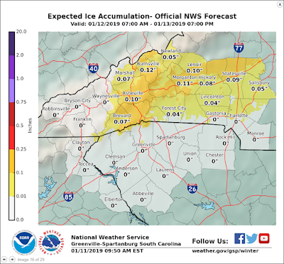
The slipperiness of ice will be the big concern, but Haywood County may well miss out on that as the warmer temps push back in from the SW.  This NWS graphic shows us breathing a sigh of relief as we don't need more travel woes and possible power outages.

(CLICK TO ENLARGE)
Saturday will be the colder of the days, and may start as all snow in bursts, with the sleet and freezing rain mixing in as the day and night wears on.  By Sunday, any precipitation switches over to all rain as the day progresses, ending our concerns.  

I'll update if necessary early Saturday morning.


Bob