Wednesday, April 27, 2011

STRONG STORMS TODAY/TONIGHT

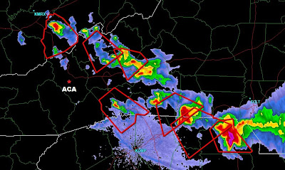
Chances for severe storms here in ACA the next 18 hours or so have heightened rather noticeably.  While storms are possible anytime today, the most likely window for damaging storms will be from 6p through 3am.  A tornado watch already exists up to the NC border in north GA, and I fully expect us to be under one later today.  It is going to be a very damaging day for areas in the Southeast, again, sadly.

8A WED through 8A THU (click to enlarge)

I have to adjust my travel plans today because of the weather, so won't be here should there be any ACA problems/updates....you can send info via the comments section or contact Chris Martin or John Stoeckel, as always.


Bob

Tuesday, April 26, 2011

Severe storms possible WEDNESDAY


Yet another round of headline-making stormy weather is forecast around us Wednesday.  We're borderline from being in a "moderate" risk for severe storms, which is not a good thing,  Winds, however, will be south-southwest, and I'm assuming storms will travel in like manner.  That makes us in ACA a little more protected, with much heavier rainfall expected south/southeast of the Blue Ridge Parkway where the uplifting air will wring itself out on the southern Blue Ridge. 

For severe cells to affect us, the storms will have to traverse a lot of mountainous terrain to the SW, which again works in our favor to keep severe potential limited for us in ACA.  Be that as it may, I expect us to come under a Watch box sometime Wednesday.  Rotating cells are possible if not likely, as well, and damaging winds/tornadoes are the feared component.  Likely timeframe for the worst of the worst is Wednesday night, though storms possible anytime during the day.

Just a good ol' heads up.  Anticipated road work in ACA may well be hampered by the weather, as it has been already.

Bob

Saturday, April 23, 2011

ROAD WORK: APRIL 25-26

Due to the inclement weather the past few days, as well as this weekend's holiday, road work will resume along Apple Creek Road and Staymon Road April 25 and 26 (Monday and Tuesday).  Please be aware of slow moving, heavy equipment as you drive.
 
Contact Chris Martin for more information 400-9754

Thursday, April 21, 2011

ROAD WORK THURSDAY/FRIDAY

CAUTION!
THERE WILL BE HEAVY EQUIPMENT AND  ROAD WORK 

ALONG APPLE CREEK AND STAYMOND ROAD APRIL 21-22
 
Contact Chris Martin for more information 400-9754

Tuesday, April 19, 2011

Wednesday Weather and Tornado Map

Heads up for another round of mid-day storms with attitudes Wednesday. Storm Prediction Center has ACA in the "Slight" risk category for storms at 'severe' limits.  The 'likely' window in digital modeling is from 11a til 4pm, and the main threat would be damaging straight line winds.  But, as I always say, direct lightning hits I fear worst.  ;-)  Not anticipating rotating (tornadic) cells with this one.

I still muse how fortunate we (ACA) were from the last system Fri/Sat.  We got the rain but not the storms, unlike the eastern half of North Carolina.  We've seen the damage pictures and heard the stories, but here is a map from the Raleigh Weather Service showing the Saturday tornado tracks and strengths, for those interested.

(click image to enlarge)
 
 
Going back a couple of strong storm systems before that, where those at least higher up in ACA got snow on the backside, strong winds brought down a good many trees here.  At my house, there was no damage...a lightweight snow shovel leaned up against the house and bird feeders just feet away all stayed in place with the strong winds.  However, I discovered the lid to the hot tub cover had been speared by a lichen covered tree limb, which not only stuck in the lid but penetrated over 3 inches through the other side.  I cannot imagine the wind force it took to jettison that blunted dead stick so forcefully as it did. Eeegads.


Saturday, April 16, 2011

Weather update


Just posting a radar grab of Doppler-estimated rainfall (above, scale in inches - click on pic to enlarge), with a black * marking ACA.Tornado Watch is out of our hair, with rogue storms an issue farther south and east through noon today.  Heavy rains fell on the southern edge of the Blue Ridge as well as very close to ACA, more towards Maggie. 

bob

Friday, April 15, 2011

Severe weather "heads up"

Certainly a lot of rain heading our way later today through tomorrow...the 1-2" being thrown around seem reasonable though I think 3" amounts will pop up nearby.  The bigger concern is for severe thunderstorms, and the biggest concern for ACA should be starting in the pre-dawn hours Saturday, say around 5am.  Storms should mostly be in a line that hits hard, followed by just rain, as opposed to multiple cells coming through over several hours.

Tornadoes will be popping today from what's heading our way, but not sure what rotation will be in place when it gets here (that AM line of concern).  The Storm Prediction Center has ACA in the "Slight" risk for severe storms, with damaging wind gusts the biggest threat (well, and direct lightning hits!).  

If I see any changes in the timing or intensity, I'll update later this afternoon/evening.

bob

Monday, April 11, 2011

Strong storms possible tonight

While not as prolific as the past couple of systems, this incoming cold front already has Tornado Watches posted in KY, TN. MS, and AL as I post this close to 7pm.  Having gotten up at 12am for weather work this AM in Charlotte, I'm doubtful I'll be up to ammend this post as storms get closer.  I'm home in ACA, but heading to sleep before storms get here...they'll arrive just before midnight and potentially last several hours.  Tornadic cells doubtful, but straight-line winds and hail are anticipated where the cells form in Haywood County.  Worst of this will occur by AM commute, if not before.

Bob

Sunday, April 10, 2011

Storm wrap-up

We dodged major headaches Saturday; by the time the front got to us, it was past sunset and the storms fizzled out.  Click on THIS LINK to see the myriad storm damage reports in our region.  

The overwhelming majority of reports were hail, and large damaging hail at that.  Oddly, no reports (yet) of tornadic type damage, even with the radar-indicated funnel formation.

Bob

Saturday, April 9, 2011

TORNADO WATCH extended

830p radar grab, Saturday 4/9/11 - click to enlarge
Our tornado watch covering ACA is now valid through 2am.  Most severe cells approximate to a slowly sagging frontal boundary, and storms simply have not quite gotten overhead yet.  Nighttime may well curb the severity of the storms, but fully expect some activity over the next several hours.  All is a done deal for tomorrow (famous last words!).  You can see other info in the prior blog post.

Bob

TORNADO WATCH this evening

UPDATE @ 550p in GREEN below

Effective until 9pm, the National Weather Service has issued a TORNADO WATCH for ACA.  As I type here just after 2pm, the nasty stuff is in KY, NE TN, and one big cell around Mt. Mitchell, moving east and away from us.  In fact, right now all NC activity is north of I-40 corridor, and nothing presently in line to head our way.  That can obviously change as the afternoon wears on.

Typical strong winds, large hail, brief but heavy rains are always on the table.  Will update as necessary.

First radar scan below taken around 5:35p...nasty stuff has stayed out of our hair, but storms popping west side of Smokies so I expect some storms before too long.  Second couple of pics are what should have been a tornado on the ground on Highway 74 around and east of Shelby, that I snagged earlier.  Many reports from that cell of hail up to baseball-sized...ouch!  

Bob

(click on pics to enlarge)

540p Knoxville radar scan; cells moving E/SE  


Potential funnel to left, east of Shelby on Highway 74

swinging around looking SE into SC with funnel on the right


Monday, April 4, 2011

Tonight's weather: update

Read prior post for larger view...this is an update for the next few hours only...

Incoming storms now are minor and part of a precursor frontal situaion.....this is NOT the main event, here as I write at 4:45pm...

(click on images to enlarge)


THIS next image is the big dog on the porch, a few hours away as I type this at 4:50pm.....this is the one worth watching....


All this post is to say hang tight as the proverbial fat lady has not yet sung at the opera.  Wheeeeee.  I just got back to ACA today and was looking at all the wash issues and trees down for the first time...all I can add is mo' comin' tonight.

Bob

Weather concerns short term

Early spring continues to be its volatile self...temps really warm today, and the main batch of thunderstorm activity shouldn't roll into Haywood County until after dark (lasting through a good bit of the overnight hours).  

There will be a good bit of severe weather breaking out in TN today, especially after lunch; while the west-to-east movement means the Smokies will absorb a good bit of the atmospheric energy for us, we could still see some severe cells make it our way. No watches or anything at this time, but I wouldn't be surprised to see one hoisted for us by late this afternoon.

Rainfall amounts could be prodigious, as well. 1-2" is expected. which means more washing along ACA roads.  Heads up for the early Tuesday AM commuters of the leadfoot variety, especially for gravel washes.

Early Wednesday morning we should have lows in the 20s for a good freeze, but from there on out the temps really warm on through the weekend.  If you have any tender blooms outside, you'll have rain-free time to prep them most of Tuesday.

Bob