Tuesday, January 30, 2024

LIGHT NW FLOW TONIGHT

There really are no big changes to what I wrote early this morning.  Technically, there is in place a HWO (Hazardous Weather Outlook), but no winter advisories or warnings like last time (which didn 't matter to a hill of beans). It calls for 1-2" above 3500' (upper ACA), one of those things that makes one yawn over the sameness of so many little events this season.

Ah, but we know what a little snow on the roads can do to safety.  The ground is warm from today, so I'm not anticipating serious road issues for ACA.  Lows only around 28-31, with highs trying to reach 38-42, so any accumulations would be melting as sun returns.  And from there we only warm up this week, so this is really a baby event...though I'll reserve judgment until I'm sure we don't get a surprise 2"+.  

If needed, I'll update early early Wednesday morning.  Like 4am if not earlier.


Bob

LIGHT ACCUMULATIONS OVERNIGHT?

 Another winter nuisance event will pass through overnight into early Wednesday morning.  As I type at 415am, there is no Advisory or even a Hazardous Weather Outlook put out for ACA, but it's a little NW flow event that could lay down an inch or two in upper ACA.

For now, just a heads up.  I'll clarify and adjust later this afternoon.


Bob

Monday, January 29, 2024

ROAD/WEATHER UPDATE


Thanks to a lousy communication delay from the school system, I went ahead down Apple Creek Road around 5:20am, only to find out at the bottom that school was closed.  Oh well, into town to get gas and a few groceries...except stores don't open until 6am, 7a for Food Lion.  Oh well.

I came back up to Staymon Road around 630am and here is what I encountered.

32 degrees at the gate. minor snow amounts on non-road surfaces, road clear.

31 degees around the blue roof house (3500'), and the higher you go the more snow there is.

Double hairpins: snowy, first big area for that.  From there to Staymon there were passages of white, but I never slipped (4WD, etc.)

I can't speak for the roads past Staymon, sorry!

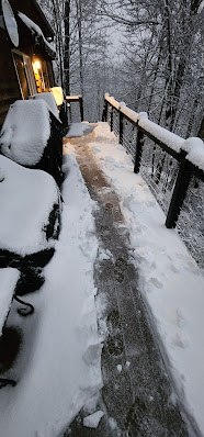
30 degrees at Staymon and snowing.  But for those on Staymon, it is exceptionally clear on the slope (read wide dark paths for tires), and then all snow covered on the flat past Dean's.  My driveway was covered and slick as a trout so I parked at the bottom and walked up.

That's all my news from Lake Wobegon.  Be careful...temps should warm some later today and get rid of any road issues.


Bob

Saturday, January 27, 2024

WINTER STORM WARNING POSTED

 A WINTER STORM WARNING has been posted for Haywood County for elevations 3500 - 4500' (upper ACA) for 2-6 inches of a wintry 'mix' of precipitation.  Click HERE for the official wording.  6-9" for elevations above 4500', but ACA tops out around 4000'.  The warning starts at noon Sunday and continues through noon Monday.

Interestingly, the NWS is seeing something I'm not seeing in my modeling, be it the NAM, GFS, and EURO.  I was thinking maybe 1-2" tops for upper ACA, so I was a bit surprised to see the warning and amounts come across my phone.

This will be a NW flow event as cold air and wrap-around moisture move in behind a cold front.  Good news we get cold air but not a super deep freeze.  Still, the concern is that this won't be pure snow, so icy 'stuff' will work in, complicating road conditions here.  And we had a LOT of complications with the last event.

I'll be here on the mountain and will update as needed, be it Sunday afternoon or Monday morning.


Bob


Thursday, January 18, 2024

WINTER WEATHER ADVISORY

Here we go again...

A lot of us are still dealing with the copious snow up high, but now comes in a system that is messy and accumulating, possibly like we just experienced.

There is one key difference: this Advisory starts at 7pm tonight and is in effect for 36 hours, until 7am Saturday.  Click HERE to read the official statement.

Friday's temps fall, probably as dramatic as they did Tuesday morning.  Single digit lows are once again expected Saturday morning.

This is not a nice snow event as sleet, freezing rain, and some rain will be mixing in, to create a slippery mess.

I'll update as needed with new information.


Bob

Tuesday, January 16, 2024

APPLE CREEK ROAD

 Apple Creek Road has been plowed and salted with a hybrid salt, but not sure it will work down to the single digits tonight.  Mind you, Apple Creek Road is not clear where there was snow/ice, so take it slowly. If Staymon was any indication, side roads were not plowed. 

I was amazed this morning looking down into the valley to see no snow whatsoever down there...it was an elevation snow, and the rain/snow line was where the heaviest dumping occured in upper Apple Creek Acres.  

But wait, folks....that's not all...

Thursday night is yet another round of wintry precipitation.  More on that Wednesday afternoon/evening.


Bob

ROAD UPDATE TO COME...

End of Staymon, ~4"

Ended up with around 4" of heavy wet snow on top of heavy sleet/slush here at home.  I was surprised that we didn't have a power outage, given the weight of the snow, so counting our blessings for that.

(new)  In 2 hours my temp has dropped from 34 to 22 degrees.  Cold is arriving, to say the least. AND....

ACA is in a Wind Chill Advisory from 2pm today through noon Wednesday.  Dangerously cold wind chills incoming...read HERE.

When I get word about plowing, etc., I'll post it here.  Keep in mind that with tonight's projected low somewhere around 4 degrees, our road salt will be ineffective at that temperature.  Salt you buy at Walmart, Lowes, etc. will work around your house, but the road salt doesn't work when temps are below the 20s.

With that said, get your shoveling done before the deep freeze hits.  Stay tuned....


Bob

Monday, January 15, 2024

APPLE CREEK ROAD: TROUBLE

I just made a run to the trash facility and back, and the changes, as in deterioration, were dramatic.  34 at the bottom, 32 at the double hairpins, and 31 on Staymon and dropping.  Road is white-covered and very slippery...and I was in bulldog gear and snow mode, and I STILL started sliding above the upper hairpin where the road begins to level out.  I BARELY made it up Staymon and then didn't even attempt my driveway. 

This is wet snow on top of wet sleet/slush, a lose-lose proposition.

The rapidity of the worsening road was quite eye-opening.  While we dodged the first part early this morning with surface temps too warm to accumulate much of anything, that has now changed as we won't see 32 until Thursday afternoon (though some in partial sun or down low could Wednesday afternoon).

Stay off the roads is my advice.  It was okay on Mauney, but it's a matter of time as temps drop.


Bob

Sunday, January 14, 2024

WEATHER WOES INCOMING

Haywood is the County left of "A" in Asheville, FYI

Once again, I'm not posting to talk about 4" of snow that will fall in an event and be done...we can't be that lucky.  What's coming in starting after midnight tonight are bands of precipitation that will have sleet, then snow, then rain/snow, then snow/sleet, then rain/snow, all very spread out and not at once.  By Wednesday are the coldest temperatures we've seen this winter, with projected lows Wednesday morning in the single digits.

We are currently in a Winter Weather Advisory from 1am Monday through 7am Tuesday.  If that changes, I'll update...from the above map you can see east TN is going to catch more of the wintry weather, so if you have to head into TN be very aware of that.  Click HERE to read the current advisory as I type at 5:20am.

Whatever sticks Monday into Tuesday stays, which I expect to be snow on top of sleet/ice. There could be some slight melting Monday afternoon, but that may make for an icier surface on roads.  Once we dip bvelow 32 degrees Monday late afternoon, a lot of us won't see temps above 32 degrees until Thursday afternoon. 

The wildcard in all of this (besides NFL wilcard games!) is how much will accumulate.  The models have been trying to nail down jello with this glop, and the advisory takes a broad brush and goes 1-4".  For Apple Creek, my favored 'looks' are in the 1-2" range by Tuesday 7am, with 3-4" very close by.  The trend the past 48 hours has been for the snow amounts to increase along the TN border areas, so I'm preparing just in case it gets a little heavier.

My biggest concern will be the roads and the level of iciness under any accumulations.  Roads will be VERY slow to improve in this type of event, and I'm talking a couple of days.  I doubt there will be enough to warrant plowing, but I'm suiting up my UTV today just in case. My hope is it won't be that bad, but I'm skeptical at this point.

I'll update late this afternoon if I see significant changes to the above, and  I'll be here for all of our fun and frivolity.


..

Bob

Wednesday, January 10, 2024

WEDNESDAY A.M. UPDATE

With 1" of snow, tops, here on Staymon, and 25 degrees, my concern is for any ice underneath.  I don't need to tell you that yesterday's heavy rains started to cause problems with regional creeks and rivers, especially toward Cruso.  And where you have seeps or springs that were continually pushing out water onto roads, those areas are sheer ice...now covered in snow. 

I have zero idea what Apple Creek Road is like, but we have several spots where there is surely ice underneath.  When I get any information, I'll post it here, but a lot of folks seem to use the Facebook page to do so as it's an easier interface for real-time commentary.  FB link is HERE.


Bob

Monday, January 8, 2024

HANG ON TO YOUR HATS....NO REALLY

 Mr. Toad's Wild Ride is coming to town starting this evening and running through Wednesday morning, to the tune of strong winds and a chance for light wintry precipitation in the predawn hours of Tuesday and Wednesday.  

Sunday aftenoon, and the ultra-light AM snow hung on

First, I was amazed that our expected light, light snow shower early Sunday morning (which at home here on Staymon was only about 0.1") covered absolutely everything, including the driveway.  And it stayed all day thanks to our shaded NE exposure.

A potent storm system will arrive tonight bringing with it a High Wind Warming for those above 3500' and a Wind Advisory below 3500'.  Whether we get the potential gusts approaching hurricane force winds remains to be seen, but what works a bit in our favor is that the winds will be out of the S/SE, which means Laurel Ridge blocks the brunt of it.  You can read the advisories HERE.

Both early Tuesday and Wednesday mornings there is a chance for some precipitation to be wintry in nature, be it snow or a wintry mix.  Winds will help preclude accumulations of any note, but may make for slippery surfaces.  It's very little if it is measurable, just suffice it to say it's a trypical 'heads up' for the next couple of days.  

I'll be staged for power outages and potentially trees down across the road just in case.  So if someone tells you to go fly a kite, get one that has a Kevlar reinforced frame and some rope instead of string...and let me know how that works out for you...   :-)


Bob

Friday, January 5, 2024

WE'RE THE BENCHWARMERS, NOW...

A little snow humor for y'all...


Looks like Haywood County (yellow dot, below) will be sitting this one out, in terms of any substantial wintry mix or light icing late tonight into Saturday morning.  Even the snow component has disappeared for ACA, or if it makes an appearance, it will be short-lived.  Rain ultimately rules, after some sleet and freezing rain.


Current Map of Weather Issues

We DO have a Wind Advisory that will kick in from 12am through 9am Saturday, for our higher elevations.  But all of the purple Advisories and pink Warnings in the above map are for icing concerns.  This is a classic wintry mix that may start as snow, then mix with sleet, freezing rain, and then rain, with ice accrual being the reason for said categories.  The I-40E and I-26E corridors may be problematic starting after midnight but especially early Saturday morning, so travel with caution those directions.

We have a few little burps of snow flurries or showers over the next week, the first chance being the pre-dawn hours Sunday morning.  But there are no travel concerns at any point in time for now.


Bob

Wednesday, January 3, 2024

SNOW/MIX AHEAD

The weather is still pussy-footing around in the wintry weather department so far this season.  You might see a snow flurry/shower this evening, but it won't amount to anything.  The ground is rock-hard here at my house as I can't stick anything in the ground by hand, so with the next round of precipitation late Friday, it might make for slippery roads for a while.

Snow looks to be a sure thing kicking in Friday evening/night, but temps will be borderline cold enough to support it for more than several hours before it ticks up and we switch to sleet, maybe some freezing rain, before it becomes all rain Saturday morning.

Any accumulation would be hampered by the reduction via sleet and rain, but 1-2" is reasonable to expect.  Originally, the EURO model had us 6-8" for a couple of days, but has since pulled way back, just as it has with every little system so far this season.  

I'll update if needed Friday. Let the milk and bread stay put on the shelves 'til next time...


Bob