Monday, January 25, 2016

MONDAY A.M. UPDATE


At least here near 3800' we had an inversion all night..been sitting at 39 degrees since I got up at 4am.  Takes refreeze out of the equation higher up, but I see low 20s on the map from typical valley locations.  Somewhere on your way down from higher up, you'll go from slush to hard ice.  Slush is still what I call 'wet ice' and very slippery, but today's weather is good news for travel to try and get back to normal in Apple Creek as we all warm above freezing, and rather nicely so.

Made several nighttime trips up and down Apple Creek Road and had zero issues in 4WD-high.  I played around and switched to AWD and definitely slid some, and rest assured 2WD will be even more wiggly.  For those that went out, you'll agree most of upper Mauney Cove Road is horrible, as well.

I'll be heading out very early, and IF I have something noteworthy to I'll post it in the comments below.  Speaking of noteworthy, some of you may already know this, Mt. Mitchell picked up 66" of snow from this storm - a new record.  You can read about it HERE

Get ready for a great day of melting...Tuesday rains may well take a turn to wintry mix as we head into Wednesday.

(7:15am UPDATE: I just started glancing at Wednesday and already the NAM has ACA in a 2-3" range with the GFS with 1".  I'm used to seeing the balance in reverse...will post more when models have honed in better,) 


Bob

Sunday, January 24, 2016

SUNDAY AM UPDATE


For those on the mountain that don't already know it, a good dose of patience can go a long way in making for a workable situation for all.  Plow Mike (that's what I call him!) is good about making calls to update those that are waiting for their driveways to be plowed out. Such heavy snow amounts really slow down the plowing process, so they had to call it quits at darkfall last evening.  Good clear sunny day ahead, with highs above freezing, and Apple Creek will have the remainder plowed today.  You can refer to prior posts for Mikes phone #, other info, pictures, etc.

Many of you may know this cheap trick that I sure have to use: dealing with frosty windshields, cemented locks and car doors, etc.:

Take an old spray bottle
Pour in one bottle of isopropyl or rubbing alcohol
Take that empty bottle and fill it half full with water
Mix up in spray bottle.  

Keep it in your car or garage, and next time you have frost, forget the scraper - just spritz the solution on and it all disappears.  The freezing point of that mixture is over 100 degrees below zero, so it always works. Spray on anything that is frozen or has ice build up, and you'll be good to go.

Now if only I had a tanker truck of that so I could pour it on my driveway.....


Bob

Saturday, January 23, 2016

SATURDAY UPDATE

Well, looks like it's all over but the shouting.  An occasional snow shower from the NW could blow through, but our accumulations are done.  I topped out right at 12" here at the end of Staymon, and numerous reports around the greater region range from10"-20" in the higher elevations.  Thankfully, minimal wind and icing let us keep power, and the plow is on it's way this afternoon.  If you didn't see the prior post, M&S Landscaping will be here to take care of our roads.  Should you wish them to take care of your driveway, please call MIKE directly at 828-734-2861 and get on the list.

Click HERE for a preliminary listing of snow totals in the GSP forecast area, listed by descending amounts. Almost 3 feet at Newfound Gap in the Smokies...ouch!

For a brief spell, the snow/clouds lifted to let me take a few quick shots N/NE from home (click to enlarge):


Highs should get a little above freezing Sunday, and more so Monday with nightly refreeze.  This snow has an icy bottom to it, so be cognizant of that as you start moving around.

Bob

Friday, January 22, 2016

*NEW*-PLOWING INFO-PLEASE READ

UPDATE:  The following is from our HOA President Owen Fulghum:

"We are taking the advice of our plough guy to clear the roads in two passes. The current plan is to make a "quick" pass this afternoon (Friday) to reduce the bulk and then a thorough scrape and asphalt salting after the rest of the snow falls later tonight and Saturday. He suggested this will cost us fewer hours. We'll see - and then use what we learn for future decisions. If you would like your driveway cleared (probably a waste prior to second scrape), you may arrange with Mike from M&S Landscaping at 734-2861."
_____________________________


The end of Staymon @ 8am.  7" and adding - had to clear off ground-level satellite dish! (click to enlarge)

Well, here we go!  Starting a new page for current storm info and data - please refer to prior posts for other information and where we might be heading.  At 1230am we were getting steady sleet, so this will have an icy belly.  By 130a there was a solid but light coating of snow, and now, of course, we're 7-8" and still going.  We may hit a lull later today, and MAYBE get some switch to sleet again, though I've been holding 26-27 degrees here all morning.  Later tonight, as the low runs up the coast, we expect a bigger push of snow again, so this is a long long way from being done.  Hoping we keep our power on, but chances for those issues increase late today.


I'll pass along interesting info as I run across it here. Up around 10" as of 1:30pm or so...temp still holding 26-27 degrees, snow still falling. 


There was a path cleared for the pups...

Birds lovin' their unsalted peanuts


How I like my bowls of ice cream...


Bob

Thursday, January 21, 2016

HUNKER DOWN: THIS IS BIG

Thankfully it warmed above freezing this afternoon, and although Apple Creek Road is still snow-covered from the curve above the blue roof house on up, it has helped lower down.  Don't underestimate the need for good tires and tread, first and foremost, up here. Once you lose grip and slide, momentum will take you places you'd rather not go.

This incoming system keeps growing more hairy, like a wintry Medusa.  The NAM has become peculiarly hot and heavy with ACA in a 14-18" range.  The GFS has bumped up a little for ACA with 8-12".  The National Weather Service zone forecast for Lake Junaluska is a wide 10-20" range.  My earlier 6-10" thought a couple of days ago has vaporized.  The higher up, the more snow, even here in ACA.  There could be as much as a 6-8" difference from the top to the bottom. (Click on images to enlarge: ACA is roughly where the black asterisk is):

NAM 7a THU MODEL RUN
GFS 7a THU MODEL RUN

The fun begins before midnight as we get rain, then some sleet mixing in, with snow joining the fray before kicking over to all snow after midnight.  It continues all day Friday, with a possible heavier period of snow Friday night.  By Saturday, the majority of the accumulation will be done, with wrap-around snow showers continuing intermittently, possibly into Sunday morning.

Breezy conditions may make for power outages, so I've filled a tub up with water for flushing and jugs for drinking water, just in case.  Candles ready, all devices charged.  Cameras ready to roll ;-) .  Plenty of activity in town today, and rightly so...just hope folks weren't lulled by the rather nice afternoon.

If we do get the monster side of this storm, don't expect to travel in Apple Creek anytime soon.  No sense in attempting to plow/treat until it's wrapped up, so plan on sitting for a good while.  Back 5 or 6 years ago I had 18" at the end of Staymon on Dec. 18...the plowers had a big equipment failure which stopped them a couple of days and I didn't get out until Dec. 24, 6 days later.  That's the type of thing that is possible up here.  Thankfully, this has been a great day to fill the coffers.  Now we wait.

Bob

THURSDAY AM UPDATE

I'll be heading (SLOWLY) down shortly from the end of Staymon, and it may take 2-3 hours for me to post an update.  Between 4am and 6am the temp dropped from 28 to 24 degrees...the tire ruts must be extremely icy, but we were fortunate that minimal freezing rain/sleet fell after the flurries before midnight.

Today is 'calm' with temps getting above freezing, certainly by this afternoon.  This is the day to take care of tire repairs, grocery runs, etc.  After midnight, our wintry mix begins, and it will be a mixed bag to be sure.  The more sleet and freezing rain mixes in, the less the total accumulation will be through Saturday.  Plenty of snow to figure in, though.

My 6-10" gut call for ACA is actually a tad under guidance which hints at 8-12".  The 1p NAM run yesterday had us in 16-20", but it backed off to the 7-10 range (for now?).  With a system like this where 1 degree makes all the difference in the world. 10" of snow can turn to 18" in a heartbeat, so there is that risk with this sytstem.

I'll do my best to post an update later this morning ...just depends on errands I have to take care of first.  There are numerous cars off on the side of Apple Creek Road, so please execute caution and SLOW speeds heading down this morning.


Bob

Wednesday, January 20, 2016

DANGEROUS ROAD CONDITIONS

Just crawled up Apple Creek Road, and was the only car up past Dawen in several hours. Several cars off on the side of the road and in ditches, none blocking the road as of 240pm or so. I slipped and slid in my 6,000 pound lead sled, but made it home via 4-wheel high.  Measured 1.2" on my deck.

The temp has apparently jumped up to 36 here. 37 at Chris Martin's house...but we're not done with precip and the temps will be going down.  All that to say the snow is very slippery given the melting and travel is not advised...and no one without 4 wheel drive (not all-wheel) should attempt it at this time.

Off and on snow will continue a while, and there may be a period of freezing rain before we get to midnight, and then quiet.  Temps are expected to be in the mid and upper 20s, so icy conditions are a given in the morning.  Sure, it switches to rain on Thursday and should help out a good bit.....BUT....

The Friday-Saturday forecast is changing...this will be our big snow event so far this season.  What looked like a cold Friday rain is now looking like a snow-sleet mix.  After supper time, it will switch to all snow, lasting into Saturday.  I'm not set on snow totals just yet as the current system is contaminating models I use, but 6-10" is a good guesstimate at this time for ACA.  

I'll use this space for now to communicate more info...please refer to prior posts for more storm information.


Bob

Tuesday, January 19, 2016

WINTER WEATHER ADVISORY

(UPDATE below...)

It's always a coin toss whether to amend a prior post or post new....so will post a short new one and tell you to go to the previous post for more details.

ACA is under a WINTER WEATHER ADVISORY from 7am Wednesday through 7am Thursday.  1-2" of snow, followed by some freezing rain well before sunrise, before it goes to all rain later Thursday morning.  Slick travel is expected, especially after the  noon hour for us. The ground/roads are now very cold, so conditions will deteriorate quickly after onset.  It's not much snow for now, but it takes little to send vehicles off the road.

Friday evening through Saturday is Snow Round #2, potentially a bigger event.  More on that later.

UPDATE @6:50am - As I was driving down our mountain, Haywood Schools closed.  My driveway and Apple Creek Road was snow covered down to around 3400', snowing rather nicely.  I had zero slippage issues, FYI.  However, I won't be back on the mountain until 2pm so won't be able to report anything.  Anyone with any reports are welcome to post them in the comments section.


Bob

TRAVEL ISSUES LIKELY THIS WEEK

Let the wintry pattern begin.  Ended up with around 1/2" of snow Sunday morning, and now we've had a true polar air mass move in.  My house is largely in the shade this time of year, and I had a low of 10 and a high of only 16 at the end of Staymon. 2 degrees as I type this morning, with the deck making random loud popping noises from the contractions.

By Wednesday afternoon, highs are forecast to get just above freezing, but round #1 of precipitation moves in, and will most likely be snow that afternoon. MY CONCERN: we've had bitterly cold temps, so ground and roads are quite cold.  What falls will stick and stay, unlike Sunday.  Roads could deteriorate rather quickly with a good snow burst. Overnight, it will be occasional snow, but possibly mix with freezing rain by Thursday morning. I see an inch or two for this push of wintry precipitation. 

Thursday's high is supposed to go well above freezing, 40s, with freezing rain switching over to rain. Thursday night will be rain-snow mix, and right now the forecast low is around 33-35 degrees, holding almost steady through the day Friday with anticipated rain. Friday night through noon Saturday, it goes back to all snow, and most likely the best chance for inches of snow.

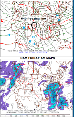
IF the low would travel just 100 miles farther east, this would be all snow and a huge mess.  As it is, the low looks like it will travel right along the Blue Ridge, bringing a good amount of rain Thursday and Friday.  These maps show the NAM and GFS in agreement about the path of the low over the  mountains.


Any accumulations of snow/ice from round #1 should dismantle by Thursday early afternoon.  At this time, both the NAM and the GFS are putting down 2-3" of snow, but I know for a fact the NAM can't see Friday night yet.  This posting isn't for amounts just yet, just a big ol' "heads up" for potential road issues just ahead.  I'll cover more amount details later.

Bob

Saturday, January 16, 2016

NEW: WINTER WEATHER ADVISORY

(5am update below)
Here we are in mid January, and outside of a solid dusting (above 3700') a couple of weeks ago, we've had no snows to deal with.  Good for the ol' budget, of course.  Plenty of cold air spills in now that the polar jet stream has shifted to the eastern U.S. more, but the wet systems to the south arrive only when we're in the warm sector ahead of the cold.  Picked up 0.96" in my gauge Friday, with the highest peaks getting wet, heavy snow.  This was the system I saw two weeks earlier that pointed to a big snow....got the moisture, not the cold.  

Below are two pics from Friday late afternoon/evening, after the rain moved out.  The first is looking out to Chambers Mtn. with yellowish late afternoon sun, followed by a wider shot in the blue cool of evening, basically a view north (from end of Staymon). Click to enlarge pics.


Overnight tonight through Sunday morning, we could see another round of snow showers from the northwest that may give up to an inch of snow in some spots.  The NAM is stingy with more of the dusting scenario, but the GFS ran a bit hotter and heavier in its overnight run with ACA in the 2-3" range, up from a steady 1-2" range for previous model runs.  The consensus in professional ranks had been that the GFS is too heavy, although it alone predicted that heavy dusting event where the NAM saw nothing. Should be more snow Mt. Mitchell north, but our part of the mountains is in the tail end of the moisture flow. However, after I posted this, the National Weather Service has bumped up their thinking more towards the GFS.

ACA is in a WINTER WEATHER ADVISORY from 2am Sunday through noon Sunday.  3" at the highest peaks, 2" for elevations like the top of ACA @ 4,000', and up to 1" in the valleys below 3,000'. 5am update: originally I'd said 1" up top and 1/4"-1/2" down low, and at the moment, I doubt we'll get that.  It's 28 and we're socked in clouds with nary a breeze...and it's the type scenario that hints at minimal anything at the moment. Moisture moving well just to our south, though. ALSO, was chatting with the NWS folks at GSP this morning and this is the first winter weather advisory for ACA since March 5 of last year!  That's pretty amazing...

Since I first posted this, I went back to check subsequent model runs.  The snow maker is a low sweeping across the FL/GA border up the coast and even the NAM is putting several inches of snow down on the I-85 corridor now. Looks like western NC is just a bit too far away to get more snow.

Deep cold plows in for Monday and Tuesday, with single digit temps likely early Tuesday morning. It will remain below average temp-wise for the entire week, with windy conditions Monday, a day where I don't expect to get much above 20 degrees for a high at the end of Staymon.

For those not on the mountain, we had very windy conditions last Friday, Jan. 8th. Falling trees cut power to just under 60 homes here from 3:20p to 5:30p, roughly.  Duke Power-Progress Energy has a great response team and information update.  For those that haven't put this number in their cell phone, the number to call and report an outage is 800-419-6356.

Bob