Friday, September 23, 2011

FRIDAY evening: quick notice

Only because I live here, and I am the primary "Keeper of the ACA Blog", I wanted to pass on the invitation for those looking for something unique to do this evening, on short notice.

While I still fill-in with weather, I moved to Apple Creek Acres to escape the rat race and focus on my work building and performing with my Native American style flutes, which are unique and spiritually significant instruments.  The historic Shelton House in Waynesville has a monthly artist/performer series, and this evening I'll be giving my dog and pony show about my flutes from 7p to 8:30p.  It's free, open to everyone, and is in the barn 'auditorium' just behind the house itself.
  
From  Main Street, take 276 S a short distance, and the house is on the right, right by the wonderful farmer's market area and performing arts center.

Bob

Tuesday, September 6, 2011

Cool rains continue, BUT....

Sitting here in Charlotte going over early AM data, and it looks like the really big rain numbers for Haywood County won't happen in most areas.  Whew.  While ACA has gotten a few inches (Al said we were up to 2.5" as of late yesterday, today's showers/isolated storms are more intermittent...heavy at times, but intermittent.  Could be a MUCH bigger issue, so I'm thankful for the 'blessing' it appears to be.

The bigger issue with this system is pushing to the east, where tornado warnings Monday were as plentiful as the boomers marauding my bird feeders on any given day.  Pic below is from a News 14 Carolina viewer, taken Monday afternoon not far from where I am.  More of the same today, and even farther east into the Piedmont and Coastal Plain. (click on pic to enlarge)


Bob

Sunday, September 4, 2011

RAIN: update Sunday noon

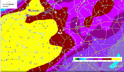
Slight adjustments to my prior post here yesterday, a bit more of a refinement.  The center of Lee's rotation still on track to go through Chattanooga and Knoxville (and the trend is even west of that track), which gives us a strong S, SE and E flow for a lot of the heavier precipitation.  Still a slow mover...but IF there is a silver lining specifically for Apple Creek Acres it's our position on the (basically) northern side our large ridge. Such a 'protective' position could cut back our storm total a couple of inches compared to, say, a friend of mine at Lake Toxaway.  East/Southeast facing slopes and sides of mountain ranges will pick up the heaviest rainfall, which could be in the 6-9" range.  While I've had ACA in a 5-7" range, it would be a blessing and a curse to get only 3-4" of rain.  A blessing for obvious reasons, and a curse because even 3-4 inches of rainfall will do a whammy here.

Below is this morning's run for storm totals, which is still underdone in the broad yellow zones.  ACA is the black star...pic will enlarge some if you click on it.


(UPDATE, Sunday 4pm:  Just checked my rain gauge from this afternoon's downpour, and picked up dead at 1.00" of rain....not a good harbinger of what's to come...)

Timing:  Storm chances pop up later today, but the steadier and heavier rains look to be here almost all of Monday and Tuesday ('definite' and 'likely' categories from 9am Monday through 4am Wednesday), with 'chance' category returning during the day on Wednesday, Thursday, and tailing off Friday.

No surprise a FLASH FLOOD WATCH has already been issued by the National Weather Service for our area, in effect from Monday morning through Wednesday morning.  I've got to travel out to Charlotte Monday, and am not looking forward to conditions, especially on the end of a big holiday.  Be careful out and about, y'all.  :-)

Bob

Saturday, September 3, 2011

HEAVY Rain Event heading our way

Tropical Storm Lee in the northern Gulf of Mexico will probably go down as one those tropical systems that, while minimal in wind speed and not a hurricane, will be proof in the pudding of just how destructive minimal storm systems can be.  The biggest issue is the S-L-O-W movement of this system, forecast to crawl up from Louisiana to the southern Blue Ridge....over a period of DAYS.


Normally a tropical system passing over us would mean maybe a day of heavy rain...Lee COULD provide periods of heavy rain over a 3-day period.  Starting Sunday night, scattered storms could move in, with steadier heavier rains getting in later Monday and Tuesday...and possibly hanging around 'til early Wednesday.


How much are we talking?  The map below, which you can click on to enlarge for more detail, shows up to 4"...and that's limited because this 84-hour outlook doesn't yet cover the whole rain event.  Estimates for ACA run in the 5-7" category for a storm total, which I can only hope is not surpassed.


Such torrential rains can do a whammy anywhere, and our ditches and gravel roads are expected to take a massive beating.  To think we won't have any problems in ACA would be folly, but at this time there is nothing that can be done...just be prepared for the strong potential of driving and travel issues, not just in ACA but around the region.  Too, with saturated soils and any good winds, keep in mind weaker/stressed trees will be more prone to come crashing down.


I'll certainly update the maps and numbers as I get them, so keep checking back. I will be leaving ACA Monday and back very early Wednesday to help out with weather in Charlotte.  While I would love for Lee's track to not pan out heading to north Georgia and western NC, that is the going consensus with more models coming into agreement with each run.


Bob