Tropical Storm Lee in the northern Gulf of Mexico will probably go down as one those tropical systems that, while minimal in wind speed and not a hurricane, will be proof in the pudding of just how destructive minimal storm systems can be. The biggest issue is the S-L-O-W movement of this system, forecast to crawl up from Louisiana to the southern Blue Ridge....over a period of DAYS.
Normally a tropical system passing over us would mean maybe a day of heavy rain...Lee COULD provide periods of heavy rain over a 3-day period. Starting Sunday night, scattered storms could move in, with steadier heavier rains getting in later Monday and Tuesday...and possibly hanging around 'til early Wednesday.
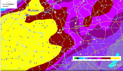
How much are we talking? The map below, which you can click on to enlarge for more detail, shows up to 4"...and that's limited because this 84-hour outlook doesn't yet cover the whole rain event. Estimates for ACA run in the 5-7" category for a storm total, which I can only hope is not surpassed.
Such torrential rains can do a whammy anywhere, and our ditches and gravel roads are expected to take a massive beating. To think we won't have any problems in ACA would be folly, but at this time there is nothing that can be done...just be prepared for the strong potential of driving and travel issues, not just in ACA but around the region. Too, with saturated soils and any good winds, keep in mind weaker/stressed trees will be more prone to come crashing down.
I'll certainly update the maps and numbers as I get them, so keep checking back. I will be leaving ACA Monday and back very early Wednesday to help out with weather in Charlotte. While I would love for Lee's track to not pan out heading to north Georgia and western NC, that is the going consensus with more models coming into agreement with each run.
Bob

No comments:
Post a Comment