3:30am Friday: Everything below stands. It transitioned from rain to heavy sleet around 230am to snow. NOT a good situation as that means below any white will be ice. Temp just dropped from 32 to 29 in just a few minutes. Wind is the strongest I've seen/heard in a long time, already with a loud noise on the roof from part of a tree. And so begins Mr. Toad's Wild Ride....
(I'll get to the incoming, serious weather in a moment. I made a 5:30pm update at the bottom)...
I decided to go to Lake J yesterday to hopefully add a Bufflehead to my Bucket List of ducks. Quite often, Buffies are waaaaay out in the middle of the lake, out of my camera range. On rare occasion I've seen them closer to shore...alas, they did not cooperate. However....I feel kind of stupid that I'd never realized there were Double-crested Cormorants at the lake, which I first saw a couple of weeks ago. In well over 10 years I've never seen them, or simply overlooked 'em. So I first present you with a handsome one (click to enlarge):
 |
| Double-crested Cormorant at Lake Junaluska |
For the past 3 years (and now 4 after Christmas), Lake Junaluska has been drained mainly to dredge the upper basin. It has put a whammy on the Atlantic Flyway migrations here as the species and numbers have plummeted, sadly, as they go elsewhere. However, there are always a few who hang around, and I got to enjoy photographing Ring-necked Ducks in several locations. They're diving ducks, so it's like playing Whack-A-Mole as to when and where they pop back up. In no particular order are a few shots of mostly drakes with a couple of hens joining in (as with any pics on here, click to enlarge) :


 |
| Ring-necked drake coming up from a dive |


(We now return to the regularly scheduled forecast:)
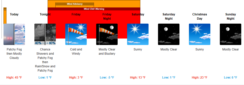
They say a picture paints a thousand words...start writing...:
 |
| Click to enlarge |
Enjoy what relative warmth we have today through tonight. Around 3am or so is when we fall into the Rabbit Hole. First, prepare for power outages. Charge batteries, have flashlights and candles ready, and whatever you need to stay warm. The wind is forecast to be very gusty and strong as the cold front passes through and well behind it. Downed trees are quite possible. The temperatures will plummet very quickly with the passage, and wind chills here in ACA will most likely run from -10 to -20 degrees. The numbers above tell the story...coldest highs I will have seen in my time here in ACA. The coldest morning I've recorded was -9 degrees many years ago, and I may well give that a run for the money. Friday is a brutal, brutal day.
Insofar as the official NWS notifications, click HERE for all the advisories (new link as of 5:30pm). Interestingly, none of the advisories talk about precipitation, only winds, temperatures, and wind chills. There simply are too many variations to try and list them here...suffice it to say it will be dangerously cold, potentially slippery, and wind chills that will make you think you're at the Arctic Circle.
*UPDATE* This is the updated addendum. It warmed up nicely today, so the roads have some added energy that may help at the onset of precipitation and dropping temps. In short order, that benefit will go bye-bye, but we'll take any gift we can get.
Precipitation will begin as light rain around 10pm. Switchover to light snow should be around 12am-2am. The amount of snow remains at a dusting to 1" on the topside, higher toward the TN border. It looks like the snow will move in from the west, not the northwest, which means the Smokies block a good bit of our intended moisture.
Keep in mind, with the crashing cold...what sticks stays, and road salt will do absolutely nothing as it will be well below workable range. If you have the sub-zero salts from Walmart, Lowe's, etc., they should work on your driveway; I'm talking about the road salt our plower/salter uses. Precipitation should be a done deal before sunrise.
Wind and cold, wind and cold...and hopefully no power outages.
Bob
No comments:
Post a Comment