Saturday, April 16, 2011

Weather update


Just posting a radar grab of Doppler-estimated rainfall (above, scale in inches - click on pic to enlarge), with a black * marking ACA.Tornado Watch is out of our hair, with rogue storms an issue farther south and east through noon today.  Heavy rains fell on the southern edge of the Blue Ridge as well as very close to ACA, more towards Maggie. 

bob

Friday, April 15, 2011

Severe weather "heads up"

Certainly a lot of rain heading our way later today through tomorrow...the 1-2" being thrown around seem reasonable though I think 3" amounts will pop up nearby.  The bigger concern is for severe thunderstorms, and the biggest concern for ACA should be starting in the pre-dawn hours Saturday, say around 5am.  Storms should mostly be in a line that hits hard, followed by just rain, as opposed to multiple cells coming through over several hours.

Tornadoes will be popping today from what's heading our way, but not sure what rotation will be in place when it gets here (that AM line of concern).  The Storm Prediction Center has ACA in the "Slight" risk for severe storms, with damaging wind gusts the biggest threat (well, and direct lightning hits!).  

If I see any changes in the timing or intensity, I'll update later this afternoon/evening.

bob

Monday, April 11, 2011

Strong storms possible tonight

While not as prolific as the past couple of systems, this incoming cold front already has Tornado Watches posted in KY, TN. MS, and AL as I post this close to 7pm.  Having gotten up at 12am for weather work this AM in Charlotte, I'm doubtful I'll be up to ammend this post as storms get closer.  I'm home in ACA, but heading to sleep before storms get here...they'll arrive just before midnight and potentially last several hours.  Tornadic cells doubtful, but straight-line winds and hail are anticipated where the cells form in Haywood County.  Worst of this will occur by AM commute, if not before.

Bob

Sunday, April 10, 2011

Storm wrap-up

We dodged major headaches Saturday; by the time the front got to us, it was past sunset and the storms fizzled out.  Click on THIS LINK to see the myriad storm damage reports in our region.  

The overwhelming majority of reports were hail, and large damaging hail at that.  Oddly, no reports (yet) of tornadic type damage, even with the radar-indicated funnel formation.

Bob

Saturday, April 9, 2011

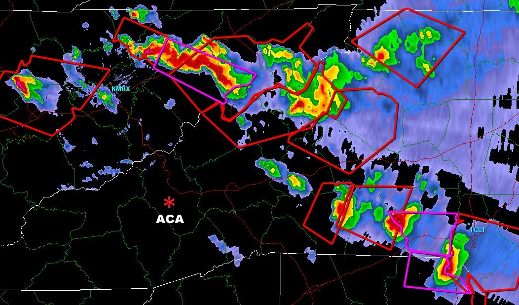
TORNADO WATCH extended

830p radar grab, Saturday 4/9/11 - click to enlarge
Our tornado watch covering ACA is now valid through 2am.  Most severe cells approximate to a slowly sagging frontal boundary, and storms simply have not quite gotten overhead yet.  Nighttime may well curb the severity of the storms, but fully expect some activity over the next several hours.  All is a done deal for tomorrow (famous last words!).  You can see other info in the prior blog post.

Bob

TORNADO WATCH this evening

UPDATE @ 550p in GREEN below

Effective until 9pm, the National Weather Service has issued a TORNADO WATCH for ACA.  As I type here just after 2pm, the nasty stuff is in KY, NE TN, and one big cell around Mt. Mitchell, moving east and away from us.  In fact, right now all NC activity is north of I-40 corridor, and nothing presently in line to head our way.  That can obviously change as the afternoon wears on.

Typical strong winds, large hail, brief but heavy rains are always on the table.  Will update as necessary.

First radar scan below taken around 5:35p...nasty stuff has stayed out of our hair, but storms popping west side of Smokies so I expect some storms before too long.  Second couple of pics are what should have been a tornado on the ground on Highway 74 around and east of Shelby, that I snagged earlier.  Many reports from that cell of hail up to baseball-sized...ouch!  

Bob

(click on pics to enlarge)

540p Knoxville radar scan; cells moving E/SE  


Potential funnel to left, east of Shelby on Highway 74

swinging around looking SE into SC with funnel on the right


Monday, April 4, 2011

Tonight's weather: update

Read prior post for larger view...this is an update for the next few hours only...

Incoming storms now are minor and part of a precursor frontal situaion.....this is NOT the main event, here as I write at 4:45pm...

(click on images to enlarge)


THIS next image is the big dog on the porch, a few hours away as I type this at 4:50pm.....this is the one worth watching....


All this post is to say hang tight as the proverbial fat lady has not yet sung at the opera.  Wheeeeee.  I just got back to ACA today and was looking at all the wash issues and trees down for the first time...all I can add is mo' comin' tonight.

Bob