Friday, December 20, 2024

WINTER WEATHER ADVISORY

Bull Elk #16, Cataloochee Valley herd

Yet another case of a big bark but only a little bite.  Yes, Haywood County is under a Winter Weather Advisory for elevations above 3,500 feet (upper ACA), for up to 4 inches of snow near the TN border.  The advisory runs from 1pm today through 1pm Saturday, BUT....

For Apple Creek Acres, I don't even see 1/2", if that, from this baby NW flow event.  All the models I reference show a rapid fall-off in accumulations as you move away from the TN border, and the most recent runs have reduced a bit more.

But it is the Christmas holiday in full swing, so even seeing flurries is kind of heart-warming.  And, should there be light accumulations on the road, know they could easily be slippery as even a light coating can send a car sliding if one isn't careful.


Bob

Wednesday, December 11, 2024

A BIT OF SNOW AGAIN...

 Temperatures will crash rather rapidly today as we head to near 20 degrees tonight.  Any leftover moisture will turn into snow showers later this morning through early afternoon, and at elevations above 3500' (upper ACA) snow showers will continue intermittently throughout the evening hours.

The first one of these I ended up with 1".  Last time I got 2".  Looks like the same sort of ballpark for this minor but bone-chilling event.

The ground certainly warmed up yesterday, which should preclude icy conditions on our roads, but slushy snow is the next best thing to ice, so use caution, as always.

-------------------------------------------

From my files:

This is Chris.  Chris is a cow moose.  When she's having a good day, she's rather merry.  Yes, if she could talk, she would say "Merry Chris Moose!"

(click to enlarge...and groan)


Bob

Monday, December 2, 2024

QUICK, LATE SNOW FORECAST FOR OVERNIGHT


Had a long day and then an evening commitment, and didn't get home until 9pm.  The National Weather Service never put us in an advisory for tonight, just a special weather statement about snowfall potential overnight.

I must say, the moisture field in east TN is fairly impressive, and the temps are well below freezing already...but the relative humidity is still around 75% right now, so anything falling is evaporating.  Over the next few hours, that relative humidity will climb and snow will reach the ground, but accumulations should be on the light side, equal or slightly less than our last little episode. 

Heading to bed shortly, just wanted to post something as I truly thought they may put out an advisory for elevations above 3500', but that was not to be.  Regardless, it'll be one cold, cold day Tuesday...with maybe a little white frosting to start.  :-)

Oh, and happy December!


Bob

Wednesday, November 20, 2024

COLD AND SNOW....AND FEMA


11/19/24 dawn burst of color, from the end of Staymon

I simply wanted to begin with FEMA...please read the prior posts about my visit and the process.  We've had at least a couple of FEMA inspectors out to see the slump and impending travel disruption above the double hairpin curves.  A fair number of residents/lot owners have already been to see them (again, read posts...EZ-peasy to get to them and talk).  The more of us living above the curve go see FEMA, the better.

----------------------------------------------------------

Looks like we're in line for our first snow of the season.  Already a WINTER WEATHER ADVISORY is posted for Haywood County for elevations above 3500'.  The call in general is for 2-4" of snow from the last half of Thursday through Saturday morning, but I am not seeing that, not here for ACA this far from the TN border.  

I do see 0.5"-1.0" of snow for the upper half of ACA (above the blue roof house across from Dawen Circle), and much lighter below that, all by Friday morning.  I simply don't see the higher amounts this far from the TN border.  This is a NW flow event, and we rarely get multiple inches of snow unless the flow is perfectly aligned along I-40 from the NW.

It will be quite cold.  It will be very windy.  Power outages are quite likely given the strong wind fields moving in, knocking down weakened trees.  I just don't see the water content needed for multiple inches here in ACA, that's all.

Early tomorrow morning, Thursday, if I see some significant changes, I'll post them before heading down the mountain at 7:30am.


Bob

Saturday, November 16, 2024

MY VISIT TO FEMA

 On my lunch break Thursday I went by the FEMA station.  It's located at the HCC building as you turn into the Industrial Park, located just downhill from Shoney's and Junaluska Vet office.  Their hours are 8am-7pm daily, 7 days a week. Click HERE to go the site if you want to read more.

You go in to an initial table to give the basic information.  I told them we have an endangered road that if it gives way will trap those of us above 661 Apple Creek Road without a way out.

They'll send you to another table where someone enters your information and gives you a piece of paper with a number on it, and they will direct you to the chairs where you will wait to be called.  

The FEMA tables and agents are all along the walls, and when called, you'll go to that table and start a long list of questions, descriptions, etc.

The key is to tell them that this issue is at 661 Apple Creek Road.  If you had additional impacts on up where our mudslides were, you can add that information.

Apparently the rules have changed just in the past week.  At first, Apple Creek could only file for a SBA loan, but they have opened that up to residents being able to  file and the money go to the HOA (I hope I understood that correctly).  

This process is only the beginning, as you will be instructed to gather some forms, bills, statements and email/scan them to a FEMA address for further continuation of the application.  That's where I am at the moment.

They will mention that an inspector will need to visit the site and that a phone call will come from one at some time and that it may come across as an unknown number...but to answer all such calls to make sure it's an inspector.  [Personally, I'll find that difficult as I am fast approaching 65 and am already swamped with everybody and their brother, sister, cat, and dog trying to sell me plans.  Plus, I can't answer calls at work, so I'll try and keep my message box cleared].

The key to all of this is for EACH LOT/HOMEOWNER TO GO THE FEMA STATION AND FILE.  The more money we can funnel to the HOA lessens the potential assessment that might be made on all lot owners to help shoulder the clean-up bill from our damages in our HOA.


Bob

Monday, November 11, 2024

FEMA AND APPLE CREEK CONCERNS


Barred Owl by home on Staymon Road

The following is from Keith Patton, concerning the dangerous slump that is precariously close to the edge of the road on the upper hairpin curve.  If you've seen the orange cones there, give them a wide berth. 

The slump at the orange cones
 

"I have been in contact with Joyce Wells at 661 Apple Creek Road concerning the road bank washout on her property. We have both been to the FEMA headquarters to file claims in hopes of getting financial assistance from them to help fix this problem. They told her that the residents of ACA who live above 661 Apple Creek Road should come in and file individual claims since they would be affected if the road bank were to cave in stranding them. I don't know what our chances of getting help are but this certainly seems worth the effort."

With the mudslides damages and clean-up on upper Apple Creek and Tannehill Roads, Apple Creek lot owners may well be facing an assessment that has yet to be determined.  Our coffers are empty, and the idea is that, as suggested, those of us above the upper hairpin curve go apply at FEMA, which is located in the industrial park just downhill from Shoney's/Junaluska Vet.  The basis for filing is that if the road gives way, everyone above it would be stranded with no alternate route to get out.  Any payments can go back into the HOA to offset our losses.  It would be a start, anyway.  If the HOA as one entity were to file, it would require 100% of lot owners to support it, which is simply out of reach.

Too, it's unclear what is even possible to shore up that slump area and prevent further erosion and potential damage.  There will be more information forthcoming, I'm sure, and I'll pass it along accordingly.  When I get the opportunity to go by FEMA myself, I'll pass on my experience.


Bob


Tuesday, October 15, 2024

QUICK UPDATE

October 10 just before midnight, NW sky

Last Thursday night the Aurora Borealis was visible in the southeast, and the internet has many much better pictures than mine.  I happened to wake up around 11:30pm and took this picture, but most of the color was in the NW sky, which for me is blocked by trees. 

 It probably comes as no surprise that with the road issues from our Hurricane Helene mudslides, paving will be tabled due to costs.  HOWEVER, the culvert cut down low will be patched before too long.  I'm told there will be news forthcoming about the damage that was done and what was involved in mitigating the situations.  

How about a bit of snow?  Tonight, a weak cold front may well give us the first flurries of the season, with a possible dusting for the upper half of Apple Creek.  We'll also see our first temps below freezing, as well. 

 'Tis the season...


Bob

Thursday, October 3, 2024

THURSDAY 1PM UPDATE

 Outside of a rare exception, there is power on the mountain.  Cell service has been good up at the end of Staymon as there is a line-of-sight to the towers on Chambers Mountain.  Cell service down low is still spotty, as is any internet, and as a result there are still a lot of cash-only establishments.  Following is what I know if you don't know already....

Ingles at Russ is still limiting people in and cash-only.  The Hazelwood Ingles is taking cards (weird trick they'll show you how to make it work).  Publix had been taking cards, but some stores have been closing late afternoon.  Food Lion is now taking cards, but limiting people in the store.  Plenty of empty shelves as they are awaiting truck deliveries.  Ingles' massive supply hub in Swannanoa was devastated in the flood, so they are slow to get supplies.  Walmart is taking cards, and lots to restock sitting in the aisles.

Gas is slowly trickling back in.  Topped off one car yesterday at the Shell on Russ, with a $60 limit for regular unleaded.  Topped off mine this morning with a lower $40 limit.  Ingles on Russ has yet to get a gas shipment, but pumps may not run without internet.  Hazelwood Ingles has had gas, but ran out as of 1030am today.  Exxon near Mauney Cove was out of gas when I passed it noon-ish today.  But ever so slowly gas is getting delivered here.

Mountain Credit Union on Russ was letting non-members get a $300 limit for a $2.50 fee this morning (not sure if they are waiving fees or not).  I bank at Champion which flooded in Canton, and the office off Russ finally opened this morning (at least the ATM), and the line was all the way down to the round-about, so I passed.

That's the essentials as I know them.  We have had a band of angels known as residents in ACA that have done yeoman's work clearing mass gravel wash-outs and mudflow debris.  I'll take another spin up that way for updated pictures, and I understand someone saved our HOA a TON of money by cutting through the massive mudslide on Tannehill, trapping the residents at the end.  There are lots of those good stories out there, and I know I speak for everyone in thanking those of you that could pitch in.

I also spoke with two volunteers with the Junaluska Fire Dept. that were riding to all the houses in ACA in their UTV, doing wellness checks.  Makes you feel good that we live in a great place. 

I'll update as I get more pertinent information.


Bob

Sunday, September 29, 2024

APPLE CREEK ROAD UPDATE

Watering hole on Hall Top

Electricity may be out all week, so says Duke Energy.  No power means no water, so if you're looking to fill jugs/containers, there is a long-standing free spring water fill up on the right soon after you head down and turn right onto Hall Top.  Or hit up a neighbor with a generator. Or simply stay with friends somewhere else.  I'm just full of good ideas...

Apple Creek Road itself is now PASSABLE to the top, thanks to efforts by some residents to clear a path through some huge mudslides.  Tannehill is still not passable, though, best I can tell.  

The downed tree and power lines at the lower hairpin have been cleared to the sides. Noteworthy is the debris slump on the downhill side of the upper hairpin curve that cut right to the edge of the pavement, a particulary major concern for the future.

So thanks to everyone that helped in the clearing.  I'm updating from my cell phone, so keeping this short (a relative term...).
 
Approaching lower hairpin going down
  
Slump on upper hairpin curve

Tannehill at intersection with Apple Creek

Upper mudslide 1 at a driveway

Upper mudslide 2 of Apple Creek Rd.

Another part of a mudslide

Lower mudslide on Apple Creek Rd.


Bob

Friday, September 27, 2024

2pm UPDATE: FRIDAY


Flooding along Mauney Cove Rd. at 7:30am

Lower hairpin before partial clearing.

Someone cut a path through the trees down on the lower hairpin curve, though wires are still on the ground, and you have to slowly take the outside of the curve to go around a suspended wire. I did make it back up to Staymon.

Reports are of more serious road and erosion issues up past Staymon Road, as well.  I don't have any other particulars at this time.

There are LOTS of power outages, and we are only a very small part (red circle below). This will probably be the longest outage we've seen in many years.

Many roads were/are closed throughout the county, thanks not only to overflowing  waterways but road damage to boot.  The extent of damage in Haywood County should be a shocker when it comes to light.


Bob

HAIRPIN ISSUES: ROAD BLOCKED


I am at the lower hairpin heading up, and a large tree is across the road and took power lines with it.  I was going to cut it up, but with embedded wires I'll defer to Duke Energy.  Impassable for now.  Buttered Biscuit is open, so heading there now. 😛


Bob

Wednesday, September 25, 2024

BATTEN DOWN THE HATCHES...

Wed. AM 19/25/24 from end of Staymon.
(Click to enlarge)

Unless you're living under a rock, you know Hurricane Helene is soon to wreak havoc in our area with prodigious rainfall and gusty winds starting Thursday but mostly on Friday.

The heavy rains we've seen today, Wednesday, is not related to Helene; rather, there is a tight jetstream trough dipping in the Southeast, with a low pressure cell that developed in the bottom of the trough and has been drawing up Gulf moisture, sending a wide swath of heavy rains along the stalling frontal boundary.  Just mincing weather words, really...lol!

The effect is the rains today and tonight and early tomorrow are simply going to soak the soil levels to the degree that when the wind fields get here Friday, weak trees will begin to topple, and I'm expecting to lose power at some point, especially on Friday.

Having worked in TV for 24 years, I cringe when I see the typical weather related stories of have this, have that, get this, get that...but it does bear repeating that I'm staging flashlights and candles, and charging batteries in anticipation of an outage.  Whereas most of our outages might be limited to just Apple Creek/Mauney Cove Rd area, this storm could cause a much wider spread of outages, which means it may take longer for power to come back on.  Just sayin'...

In fact, I'm loading the chainsaw and supplies in my car so I can ensure I get home from work the next couple of days, just in case I come across a tree down across the road.  Being overprepared beats being underprepared.

Weather will improve quickly this weekend, so this is not a very long event, but we still have to navigate the next 60 hours or so.

----------------------------------------------------------------------------

As an aside, our annual HOA meeting last Saturday went smoothly and was lightly attended, but I got to meet a few new folks in the process.  Looking ahead, October 7-ish may be when our annual paving efforts will take place, at the mercy of weather-related scheduling by the paving company.  I'll be posting the actual date as best I can when it is set, which is usually very close to the actual event.  Stay tuned!


Bob

Wednesday, September 18, 2024

ANNUAL HOA MEETING REMINDER

Muted sunrise from the end of Staymon Rd.
 (click to enlarge)

Just a friendly reminder that our annual ACAHOA meeting is this coming Saturday:

Date:  September 21, 2024

Time:  10am - 12pm
Location:  Waynesville Public Library Auditorium
                (lower level, enter from back)

The meeting will include director's reports, the latest information on road maintenance/repaving, and any new business brought up by attendees. 


Bob

Tuesday, August 13, 2024

ANNUAL MEETING AND PROXIES...AND A FEW PICS


Inspiration Point by Lambuth Inn

Just another sunrise from the end of Staymon

West Virginia White on White Violet
(click on all pics to enlarge)

By now, all property owners should have received notice of the upcoming Annual Meeting of ACAHOA, as well as a proxy and return envelope.  If you cannot attend the meeting, PLEASE make sure to fill out the proxy (your vote) and use the return envelope in a timely manner., well before the scheduled meeting.  This will ensure we have a quorum for the meeting to proceed.

Date:  September 21, 2024
Time:  10am - 12pm
Location:  Waynesville Public Library Auditorium

The meeting will include director's reports, the latest information on road maintenance/repaving, and any new business brought up by attendees. 


Bob

Monday, June 17, 2024

JUNE UPDATE, THOUGHTS, WHAT'S AHEAD

(click on pics to enlarge)


I've been meaning to post an update for a while, but I have had very little shareable news come my way.  Nonetheless, there are some things worth mentioning, so I figured I'd start with some sunrises/dawns from home.  Now that school is out and I'm not leaving the mountain at O'dark-thirty to drive a yellow tin can, I get to enjoy the beginning of new days.  Around 5:30am the birds start singing en force, and the lanscape begins to slowly brighten.  A lot of mornings it is a subtle transition, while others make a postcard.  My favorite of the shots above is the third one down, with the crescent moon hanging above the skyglow above Lake Junaluska.  Coffee seems to taste extra nice then, too.  :-)
-----------------------------------------------
Over the past weeks we've had some good rains, and if Staymon Road is any indication, the grading/rolling of our side roads some time ago took very, very well.  Very happy to see that.  I also want to thank everyone for their patience with  Apple Creek Road closing part of a day to put in the culvert down low...when paving takes place, that little ditch will be filled in, of course.  Gravel put in there did get washed out in one of our downpours.

Here's the thing about any roads, but especially our roads:  Water is the number one source of deterioration and damage, and must be controlled and channeled as needed to protect the road sides and bed.  That trouble gets compounded with freezing temperatures and water crossing the road, for obvious reasons.
-----------------------------------------------------
The upcoming HOA Annual Meeting in either late August or early September.  I mentioned this before, and some of you have talked about it.  All along our board is staffed with those that volunteer to fill the positions of president, vie-president, treasurer, and secretary, for the minimum.  You get lot dues paid (for one lot) by doing so, and the majority of work concerns paving/grading, and winter weather issues.  There are other things, of course, like lot owners that refuse to pay dues, but there is a retained lawyer to handle that.  The past few years, very few have stepped forward, which means the former board stays in place.  I think I speak for them to say they need a break as they've been in place a few years.  BUT...and this is a seriously big 'but'...

We in Apple Creek HOA are a lot closer than we think to having an outside third party take over the HOA, which is done in many areas.  Rest assured this will cause bigger issues, among others the jacking up of annual fees.  Our current $300/year fee per lot is a steal of a deal, hands down, and one of the least expensive around.  Do we really want to start paying $1,000 or more annually, which is an entirely reasonable outcome?  I'm hoping we will have those interested to let it be known.  Throwing it out there for now...
-------------------------------------------------------===

On a lighter note, the first Friday of each month from May through December, downtown Waynesville has "Art After Dark" from 6p-9p.  A lot of galleries are open, and a few stores, as well, often with light snacks (I can never spell the horse-doober word!).  Friday July 5, I will be playing and demonstrating with my Native American style flutes that I've been making for 22 years, at the Haywood County Arts Council storefront (86 North Main Street).  For those that live near me, you have heard flute music lilting through the air at times.  If you're out and about, please stop by and say howdy!
---------------------------------------------------------------

And ending on an even lighter note, bears on your deck are one thing....but how about a turkey on your car?  She was nice enough to leave a greeting card when she flew away...  :-/

Bob


Tuesday, April 30, 2024

ROAD WORK WEDNESDAY

Apple Creek Road will be closed this Wednesday, May 1, from 10am-3pm for scheduled road work.  That's all the information I have.


Bob

Tuesday, April 2, 2024

NOTHIN' LIKE APRIL SNOWFLAKES, EH?

From the vault: Bull Elk bugling, Cataloochee Valley Herd
(click to enlarge)

It's a minor thing, this cold shot incoming that will drop our temps from a high near 80 today to a low near 30 Thursday morning.  But before the cold arrives, we have pretty gusty winds coming in today and tonight, along with rain and possibly some good rumbles of thunder.  Cooler air invades for Wednesday, but more showers will be possible.  

It's the overnight hours into Thursday morning that the cold air aloft can keep snow mixing in with the (limited) rain to the surface, and maybe a temporary accumulation before melting.  Roads should be fine given the warmth of the ground and the not-so-low temps...and in case your jaw is open, we have seen snow here in May.  This is just one of those. "Aw, I was enjoying the great spring weather...". 

Good news is that the temps start to rebound after a chilly Thursday and Friday, with Sunday being the pick weekend day with sunny highs back into the mid and upper 60s.


Bob

Friday, March 1, 2024

WINTER WEATHER ADVISORY UNTIL 3PM TODAY

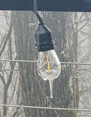
Icing on Edison light @1230pm today

Been sitting at 30/31 degrees for several hours here at the end of Staymon, and vegetation has a nice coating of ice, especially any evergreens, which are drooping down into the roads.  The National Weather Service posted our area in the advisory which you can read about HERE.  Icing is most evident above the double hairpin curves, elevation-wise. We need a lot of things, but a third consecutive day of power outages isn't one of them.

Hopefully, the temp will creep upward this afternoon and avert any problems.  The roads are fine, just be careful on your decks and stairs.


Bob

Wednesday, February 28, 2024

WIND ADVISORY AND STUFF

Repost of Ring-neck drake at Lake Junaluska years ago,  Click to enlarge.

Such a scientific word, "stuff", eh?  We all enjoyed a 4-hour power outage last night, and with more strong wind slated for this afternoon through tomorrow mid-day, it could happen again.  This area has a lot of dead/dying/weakened ash and locust trees that more easily come down in strong winds.  A Wind Advisory is in place for ACA from 1pm today for a 24-hour period.  Click HERE for details.

As our precipitation ends tonight, temps will plummet well down into the 20s, but at least the cold temps soon mitigate after one day.

In retrospect, thank goodness our surface temps stayed above 32 degrees with all the snow that was falling last Saturday.  I was fine with that!

Ah, and Leap Year is here as tomorrow is Feb. 29.  If you are wondering when leap years occur, divide any year by four.  If it divides cleanly, then it's a Leap Year.  The history of a Leap Year goes FAR back in time, in case you were wondering.  Click HERE for a good article on it from TIME.

Daylight Saving is just around the corner, but not this weekend.  It will be the following weekend, March 10.

That's all the news from Lake Wobegon, saddle pals.


Bob


Saturday, February 24, 2024

HERE WE GO AGAIN....


Dawn 2/18/2024 from the end of Staymon Rd.

A quick-hitting band of snow showers will cross our area later this afternoon and evening.  Strong winds will once again accompany this clipper, but those winds will also limit accumulations.

Speaking of accumulations, this is yet another piddly amount that may not accumulate in the valleys or lower ACA (outside of a dusting).  The higher portions of Apple Creek could get 0.25"-0.75" on the ground if a couple of the models verify.

The wind and temperatures could limit accumulations.  I woke up to 36 degrees on Staymon, so the roads should not become an issue unless there is a temporary coating from a heavy burst. Temps will fall later this afternoon en route to a cold start for Sunday.

The good news is that we'll have unusually mild weather next week, with the possibility of strong thunderstorms nearby Wednesday.  The polar jet stream is finally starting to wobble our way after exiting northern Europe, so we'll have to see if it pays us a visit sometime in March.

(raising a glass of wine...)  Salut!


Bob

Friday, February 16, 2024

LIGHT SNOW SHOWERS BY MORNING

 "Light" is the operative word.  A quick hitting shot of cold air will be in place Saturday before starting to rebound some Sunday.  There is very little moisture with tonight's cold front, but the cold air will most likely squeeze out some wintry mix precipitation through Saturday morning.  I don't foresee any road issues given our temperate days of late.  Any accumulations would be insignificant.

Winter is far from over, and we all cringe over a potential late freeze to plants and crops. But after getting last month's Duke Energy bill, I'll take all the milder weather I can get.  Just not tomorrow....


Bob

Tuesday, January 30, 2024

LIGHT NW FLOW TONIGHT

There really are no big changes to what I wrote early this morning.  Technically, there is in place a HWO (Hazardous Weather Outlook), but no winter advisories or warnings like last time (which didn 't matter to a hill of beans). It calls for 1-2" above 3500' (upper ACA), one of those things that makes one yawn over the sameness of so many little events this season.

Ah, but we know what a little snow on the roads can do to safety.  The ground is warm from today, so I'm not anticipating serious road issues for ACA.  Lows only around 28-31, with highs trying to reach 38-42, so any accumulations would be melting as sun returns.  And from there we only warm up this week, so this is really a baby event...though I'll reserve judgment until I'm sure we don't get a surprise 2"+.  

If needed, I'll update early early Wednesday morning.  Like 4am if not earlier.


Bob

LIGHT ACCUMULATIONS OVERNIGHT?

 Another winter nuisance event will pass through overnight into early Wednesday morning.  As I type at 415am, there is no Advisory or even a Hazardous Weather Outlook put out for ACA, but it's a little NW flow event that could lay down an inch or two in upper ACA.

For now, just a heads up.  I'll clarify and adjust later this afternoon.


Bob

Monday, January 29, 2024

ROAD/WEATHER UPDATE


Thanks to a lousy communication delay from the school system, I went ahead down Apple Creek Road around 5:20am, only to find out at the bottom that school was closed.  Oh well, into town to get gas and a few groceries...except stores don't open until 6am, 7a for Food Lion.  Oh well.

I came back up to Staymon Road around 630am and here is what I encountered.

32 degrees at the gate. minor snow amounts on non-road surfaces, road clear.

31 degees around the blue roof house (3500'), and the higher you go the more snow there is.

Double hairpins: snowy, first big area for that.  From there to Staymon there were passages of white, but I never slipped (4WD, etc.)

I can't speak for the roads past Staymon, sorry!

30 degrees at Staymon and snowing.  But for those on Staymon, it is exceptionally clear on the slope (read wide dark paths for tires), and then all snow covered on the flat past Dean's.  My driveway was covered and slick as a trout so I parked at the bottom and walked up.

That's all my news from Lake Wobegon.  Be careful...temps should warm some later today and get rid of any road issues.


Bob

Saturday, January 27, 2024

WINTER STORM WARNING POSTED

 A WINTER STORM WARNING has been posted for Haywood County for elevations 3500 - 4500' (upper ACA) for 2-6 inches of a wintry 'mix' of precipitation.  Click HERE for the official wording.  6-9" for elevations above 4500', but ACA tops out around 4000'.  The warning starts at noon Sunday and continues through noon Monday.

Interestingly, the NWS is seeing something I'm not seeing in my modeling, be it the NAM, GFS, and EURO.  I was thinking maybe 1-2" tops for upper ACA, so I was a bit surprised to see the warning and amounts come across my phone.

This will be a NW flow event as cold air and wrap-around moisture move in behind a cold front.  Good news we get cold air but not a super deep freeze.  Still, the concern is that this won't be pure snow, so icy 'stuff' will work in, complicating road conditions here.  And we had a LOT of complications with the last event.

I'll be here on the mountain and will update as needed, be it Sunday afternoon or Monday morning.


Bob


Thursday, January 18, 2024

WINTER WEATHER ADVISORY

Here we go again...

A lot of us are still dealing with the copious snow up high, but now comes in a system that is messy and accumulating, possibly like we just experienced.

There is one key difference: this Advisory starts at 7pm tonight and is in effect for 36 hours, until 7am Saturday.  Click HERE to read the official statement.

Friday's temps fall, probably as dramatic as they did Tuesday morning.  Single digit lows are once again expected Saturday morning.

This is not a nice snow event as sleet, freezing rain, and some rain will be mixing in, to create a slippery mess.

I'll update as needed with new information.


Bob

Tuesday, January 16, 2024

APPLE CREEK ROAD

 Apple Creek Road has been plowed and salted with a hybrid salt, but not sure it will work down to the single digits tonight.  Mind you, Apple Creek Road is not clear where there was snow/ice, so take it slowly. If Staymon was any indication, side roads were not plowed. 

I was amazed this morning looking down into the valley to see no snow whatsoever down there...it was an elevation snow, and the rain/snow line was where the heaviest dumping occured in upper Apple Creek Acres.  

But wait, folks....that's not all...

Thursday night is yet another round of wintry precipitation.  More on that Wednesday afternoon/evening.


Bob

ROAD UPDATE TO COME...

End of Staymon, ~4"

Ended up with around 4" of heavy wet snow on top of heavy sleet/slush here at home.  I was surprised that we didn't have a power outage, given the weight of the snow, so counting our blessings for that.

(new)  In 2 hours my temp has dropped from 34 to 22 degrees.  Cold is arriving, to say the least. AND....

ACA is in a Wind Chill Advisory from 2pm today through noon Wednesday.  Dangerously cold wind chills incoming...read HERE.

When I get word about plowing, etc., I'll post it here.  Keep in mind that with tonight's projected low somewhere around 4 degrees, our road salt will be ineffective at that temperature.  Salt you buy at Walmart, Lowes, etc. will work around your house, but the road salt doesn't work when temps are below the 20s.

With that said, get your shoveling done before the deep freeze hits.  Stay tuned....


Bob

Monday, January 15, 2024

APPLE CREEK ROAD: TROUBLE

I just made a run to the trash facility and back, and the changes, as in deterioration, were dramatic.  34 at the bottom, 32 at the double hairpins, and 31 on Staymon and dropping.  Road is white-covered and very slippery...and I was in bulldog gear and snow mode, and I STILL started sliding above the upper hairpin where the road begins to level out.  I BARELY made it up Staymon and then didn't even attempt my driveway. 

This is wet snow on top of wet sleet/slush, a lose-lose proposition.

The rapidity of the worsening road was quite eye-opening.  While we dodged the first part early this morning with surface temps too warm to accumulate much of anything, that has now changed as we won't see 32 until Thursday afternoon (though some in partial sun or down low could Wednesday afternoon).

Stay off the roads is my advice.  It was okay on Mauney, but it's a matter of time as temps drop.


Bob

Sunday, January 14, 2024

WEATHER WOES INCOMING

Haywood is the County left of "A" in Asheville, FYI

Once again, I'm not posting to talk about 4" of snow that will fall in an event and be done...we can't be that lucky.  What's coming in starting after midnight tonight are bands of precipitation that will have sleet, then snow, then rain/snow, then snow/sleet, then rain/snow, all very spread out and not at once.  By Wednesday are the coldest temperatures we've seen this winter, with projected lows Wednesday morning in the single digits.

We are currently in a Winter Weather Advisory from 1am Monday through 7am Tuesday.  If that changes, I'll update...from the above map you can see east TN is going to catch more of the wintry weather, so if you have to head into TN be very aware of that.  Click HERE to read the current advisory as I type at 5:20am.

Whatever sticks Monday into Tuesday stays, which I expect to be snow on top of sleet/ice. There could be some slight melting Monday afternoon, but that may make for an icier surface on roads.  Once we dip bvelow 32 degrees Monday late afternoon, a lot of us won't see temps above 32 degrees until Thursday afternoon. 

The wildcard in all of this (besides NFL wilcard games!) is how much will accumulate.  The models have been trying to nail down jello with this glop, and the advisory takes a broad brush and goes 1-4".  For Apple Creek, my favored 'looks' are in the 1-2" range by Tuesday 7am, with 3-4" very close by.  The trend the past 48 hours has been for the snow amounts to increase along the TN border areas, so I'm preparing just in case it gets a little heavier.

My biggest concern will be the roads and the level of iciness under any accumulations.  Roads will be VERY slow to improve in this type of event, and I'm talking a couple of days.  I doubt there will be enough to warrant plowing, but I'm suiting up my UTV today just in case. My hope is it won't be that bad, but I'm skeptical at this point.

I'll update late this afternoon if I see significant changes to the above, and  I'll be here for all of our fun and frivolity.


..

Bob

Wednesday, January 10, 2024

WEDNESDAY A.M. UPDATE

With 1" of snow, tops, here on Staymon, and 25 degrees, my concern is for any ice underneath.  I don't need to tell you that yesterday's heavy rains started to cause problems with regional creeks and rivers, especially toward Cruso.  And where you have seeps or springs that were continually pushing out water onto roads, those areas are sheer ice...now covered in snow. 

I have zero idea what Apple Creek Road is like, but we have several spots where there is surely ice underneath.  When I get any information, I'll post it here, but a lot of folks seem to use the Facebook page to do so as it's an easier interface for real-time commentary.  FB link is HERE.


Bob

Monday, January 8, 2024

HANG ON TO YOUR HATS....NO REALLY

 Mr. Toad's Wild Ride is coming to town starting this evening and running through Wednesday morning, to the tune of strong winds and a chance for light wintry precipitation in the predawn hours of Tuesday and Wednesday.  

Sunday aftenoon, and the ultra-light AM snow hung on

First, I was amazed that our expected light, light snow shower early Sunday morning (which at home here on Staymon was only about 0.1") covered absolutely everything, including the driveway.  And it stayed all day thanks to our shaded NE exposure.

A potent storm system will arrive tonight bringing with it a High Wind Warming for those above 3500' and a Wind Advisory below 3500'.  Whether we get the potential gusts approaching hurricane force winds remains to be seen, but what works a bit in our favor is that the winds will be out of the S/SE, which means Laurel Ridge blocks the brunt of it.  You can read the advisories HERE.

Both early Tuesday and Wednesday mornings there is a chance for some precipitation to be wintry in nature, be it snow or a wintry mix.  Winds will help preclude accumulations of any note, but may make for slippery surfaces.  It's very little if it is measurable, just suffice it to say it's a trypical 'heads up' for the next couple of days.  

I'll be staged for power outages and potentially trees down across the road just in case.  So if someone tells you to go fly a kite, get one that has a Kevlar reinforced frame and some rope instead of string...and let me know how that works out for you...   :-)


Bob

Friday, January 5, 2024

WE'RE THE BENCHWARMERS, NOW...

A little snow humor for y'all...


Looks like Haywood County (yellow dot, below) will be sitting this one out, in terms of any substantial wintry mix or light icing late tonight into Saturday morning.  Even the snow component has disappeared for ACA, or if it makes an appearance, it will be short-lived.  Rain ultimately rules, after some sleet and freezing rain.


Current Map of Weather Issues

We DO have a Wind Advisory that will kick in from 12am through 9am Saturday, for our higher elevations.  But all of the purple Advisories and pink Warnings in the above map are for icing concerns.  This is a classic wintry mix that may start as snow, then mix with sleet, freezing rain, and then rain, with ice accrual being the reason for said categories.  The I-40E and I-26E corridors may be problematic starting after midnight but especially early Saturday morning, so travel with caution those directions.

We have a few little burps of snow flurries or showers over the next week, the first chance being the pre-dawn hours Sunday morning.  But there are no travel concerns at any point in time for now.


Bob