3:40pm - heavy wet snow falling and stacking
I am one wet rat...decided to give the pups their jollies and take them for a ride and nab some pictures around Lake J. As luck would have it, the heavens opened up the entire time I was out...but the pics do tell a story.
Rain update: storm total as of 1:30p was 9.14"
Temp down to 33 degrees (as I posted the video).
In the most recent runs both the NAM and GFS are set on 3-4" for us...still think something slightly more is possible. Heavier snow now set more north and into the northern Piedmont. Linn Damon reported from the board that any needed plowing, and certainly salting will take place just after midnight tonight. Black Ice loometh, with anticipated lows in the teens.
You can read the genesis of this storm and model flip flops by checking out earlier posts. I'm glad that the 'Snowmageddon' totals aren't going to pan out. Please...
Click on any picture to enlarge it...just took these an hour ago. All over the region there is a tremendous amount of water flowing down and across roads, ACA notwithstanding. These pics are just a sample of what we've been dealing with (869 Apple Creek Road, unoccupied cabin below Jan Woodlief). Clogged ditches and culverts help to divert sheeting water down the blacktop:
Lake J is something to see...I snapped this first shot from my cell phone Wednesday morning, when the park below the dam was most flooded. The second pic was from this morning:
Loads of flotsam around the lake, here by the footbridge:
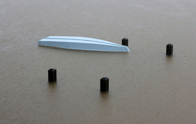
Non-floating docks are seriously inundated, as well:
I'll probably update well after supper just to 'check in'...thanks in advance for everyone's eyes and ears so we can travel as safely as possible on this beautiful mountain.
Bob


No comments:
Post a Comment